

Orte des Glaubens: Auf den Spuren des Abtes Konrad


- pets allowed
- Suitable for families
Interactive elevation profile
Create PDF
Tour-Details
Path number: 10
Starting place: 5310 Mondsee am Mondsee
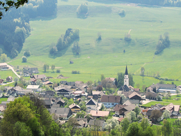
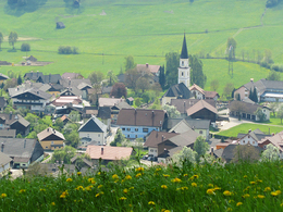
Destination: 4882 Oberwang bei Mondsee
duration: 3h 1m
length: 9,7 km
Altitude difference (uphill): 337m
Altitude difference (downhill): 268m
Lowest point: 499m
Highest point: 703m
difficulty: medium
condition: difficult
panoramic view: Some Views
Paths covering:
Asphalt, Hiking trail, Other
powered by TOURDATA
A hiking trail from Mondsee to Oberwang that has existed for centuries. The trail is signposted from Mondsee as hiking trail no. 21 (Konradweg). It begins with the ascent to the Mariahilf pilgrimage church (Pos.33), continues to Lechnerbauer, from there it runs a little below the motorway, later crosses under it and leads up the slope to the Bischofer estate, where the path leads up into the forest. Continue along the meadow path below Weinberg.
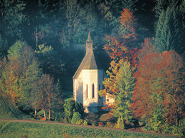
Here the well-marked forest path turns northwards to the Konradbrunn Chapel (item 123) and leads along the Way of the Cross to the Konrad Church (item 124). The bus stop is on the road in the direction of Oberwang parish church (Pos. 125).
(Please note: buses do not run daily!)
Here the well-marked forest path turns northwards to the Konradbrunn Chapel (item 123) and leads along the Way of the Cross to the Konrad Church (item 124). The bus stop is on the road in the direction of Oberwang parish church (Pos. 125).
(Please note: buses do not run daily!)
Details - hiking
- themed path
")
")
")
")
")
")
")
")
")
")
")
")
")
")
")
")
Parking
- Parking space: 150
- Bus parking space: 4
- Suitable for groups
- Pets allowed
- Suitable for teenagers
- Suitable for seniors
- Suitable for single travelers
- Suitable for friends
- Suitable for couples
- Spring
- Summer
- Autumn
Please get in touch for more information.
Kirchengasse 1
5310 Mondsee am Mondsee
Phone +43 6232 4166
E-Mail pfarre.mondsee@dioezese-linz.at
Web www.pfarre-mondsee.com
http://www.pfarre-mondsee.com
")
Interactive elevation profile
Create PDF
Tour-Details
Path number: 10
Starting place: 5310 Mondsee am Mondsee
Destination: 4882 Oberwang bei Mondsee
duration: 3h 1m
length: 9,7 km
Altitude difference (uphill): 337m
Altitude difference (downhill): 268m
Lowest point: 499m
Highest point: 703m
difficulty: medium
condition: difficult
panoramic view: Some Views
Paths covering:
Asphalt, Hiking trail, Other
powered by TOURDATA