3a Extension of Panoramaweg via Zwergerlweg
Starting place: 4890 Frankenmarkt
Destination: 4890 Frankenmarkt

Panorama path extension via Zwergerlweg
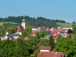
The little-used tarmac road takes us to Kritzing to a small chapel shaded by spreading lime trees and further down the hill to a fork in the road. We follow the road to Untermühlberg and turn right after a small bridge onto a gravel path.We walk along the "Zwergerlweg", which is decorated with fairytale figures and mythical creatures, between the edge of the forest and the stream to the Vöcklabrücke bridge and can already see the Trenaumühle mill ahead of us. We walk past in the direction of the B1, where a gravel path leads us shortly before to the junction of the panoramic trails and the starting point.
From the Zwergerlweg, a turn-off leads to the chocolate factory Frucht&Sinne of Christina and Thomas Kibler in Mühlberg.
Accessibility / arrival
Car:
From Salzburg via the A1 - exit St. Georgen im Attergau - turn right towards Frankenmarkt
From Vienna/Linz via the A1 - exit St. Georgen im Attergau - turn right towards Frankenmarkt
From the west - Bad Ischl - Weißenbachtal - Unterach - Attersee - St. Georgen im
Attergau - continue to Frankenmarkt
Train:
From Salzburg or Linz/Vienna with the "Österreichische Bundesbahnen" or the
"Westbahn" to Attnang-Puchheim, continue with the regional train to Frankenmarkt
Flight:
Arrival in Salzburg or Linz/Vienna, continue by car/bus or train.
Parking
- Parking space: 5
- Free entry
- Suitable for families
- Suitable for children
- Spring
- Summer
- Autumn
- Early winter
Please get in touch for more information.
4890 Frankenmarkt
Phone +43 7684 6255 - 13
E-Mail tourismus@frankenmarkt.net
Web attersee-attergau.salzkammergut.at/…
https://attersee-attergau.salzkammergut.at/oesterreich-stadt-ort/detail/430001255/frankenmarkt.html


