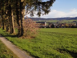
Panorama way Frankenmarkt
Very beautiful hike with great views of the mountains, where part of the route is identical to the Way of St James and leads past the pilgrims' rest station.
From the Zwergerlweg trail, you can reach the chocolate factory Frucht&Sinne of Christina and Thomas Kibler in Mühlberg.
you can admire many different sculptures. Continue over the small bridge towards the children's playground and on the other side a green area that serves as an ice rink in winter. Up to this point, the trail is identical to RW2, the Waldidylle trail.
Further on, turn right up into Pointenstraße. On the hill, we pass the elevated tank of the local water pipeline and Austria's first Ö3 weather station on the left and follow the road further east to three birch trees, where a bench invites us to take a short break.
The road continues straight ahead and a shrine and bench await us at the edge of the forest "Am Kritzinger Spitz". The view from here of the Northern Limestone Alps with the Totem Mountains, the Traunstein, the Höllengebirge, the Dachstein glacier, the Zimnitz and the Schafberg with the Lichtenberg in front is impressive. We continue to the fork in the path, where we turn right back down to the B1, cross it and hike to Stauff Castle. (Please always use the zebra crossing). Here we cross the road again and follow the Vöckla downstream along the western railway line to the subway, which we use. We then take the path to the right along the railway. We walk through the beautiful spruce forest towards Unterrain; this small village is located in the next forest clearing.
At the edge of the forest, north of the farming settlement of Unterrain, stands the Hubertus Chapel. Opposite it is a small wooden hut, the Pilgrim's Rest, where you can take a break. From here we take the path back to Frankenmarkt. Here we walk along the Westbahn railway up to the large timber factory of the Stallinger company, where we walk through the subway towards Grieß.
Here we pass the electricity plant, which was built by the municipality in 1912. Via Prager Gasse, we climb up the hill to the late Gothic, baroque parish church of St. Nicholas.
Pilgrims' rest stop on the Austrian Way of St. James in Frankenmarkt
The route of the Panorama Trail Frankenmarkt and a section of the 16th stage of the "Way of St. James Austria" from Vöcklabruck to Oberhofen am Irrsee overlap. A walk along the Panorama Trail therefore also takes you past the pilgrims' rest stop, a wooden hut built by Anton Schönberger in 2012 as a rest stop and shelter for pilgrims.
all year
Car:
From Salzburg via the A1 motorway - exit St. Georgen im Attergau - turn right towards Frankenmarkt
From Vienna/Linz via the A1 motorway - exit St. Georgen im Attergau - turn right towards Frankenmarkt
From the west - Bad Ischl - Weißenbachtal - Unterach - Attersee - St. Georgen im Attergau - continue to Frankenmarkt
Train:
From Salzburg or Linz/Vienna with the "Austrian Federal Railways" or the "Westbahn" to Attnang-Puchheim, continue with the regional railway to Frankenmarkt
Airplane:
Arrive in Salzburg or Linz/Vienna, continue by car/bus or train.
- Parking space: 5
- Suitable for groups
- Suitable for schools
- Pets allowed
- Suitable for teenagers
- Suitable for seniors
- Suitable for single travelers
- Suitable for families
- Suitable for friends
- Suitable for couples
- Suitable for children
- Spring
- Summer
- Autumn
Please get in touch for more information.
4890 Frankenmarkt
Phone +43 7684 6255 - 13
E-Mail tourismus@frankenmarkt.net
Web tourismus.frankenmarkt.net


