Poachers' Trail Pyhrn-Priel - Family (Hutberg circular trail)
Starting place: 4574 Vorderstoder
Destination: 4574 Vorderstoder
Nr. 66
4574 Vorderstoder
4574 Vorderstoder

information: Game APP
Description: The APP for the Wildererweg is no longer available!
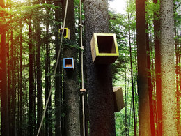
Wildererweg family - the Hutberg trail is a wild outdoor scavenger hunt for the whole family
Walk across the meadow directly to the start of the forest. At the starting point, turn right to station 1, where you will find the climbing garden and the first "Courage & Strength" station. Continue along the forest road, then turn left into the forest, where rabbits are hidden at the second "Orientation" station. Continue through the forest to the alpine meadow, where you will find the feeling box and the third station "Feeling". Cross the meadow to the Steyrsbergerreith. There is a wonderful view of the rugged peaks of the Totes Gebirge. From the rustic hut, it's all downhill. After the pasture, follow the path into the forest. Right at the beginning you will see the lookout, which forms the fourth station "Weitblick". Follow the forest path until the sign directs you to the left. Here you look for animal tracks in the overgrown hollows, which belong to the fifth station, "Sharpness".
The sixth station, "Endurance" , is optional, the path is adventurous, but the view from the "Stoderer Weitblick" platform is all the more beautiful. Once you have reached the summit, you can return to the seventh station via the well-secured path and forest trail. Here you can put your "marksmanship" to the test at the shooting range. Now you walk steeply downhill to the end of the forest, where the scavenger hunt ends at the eighth station "Wall of Fame". Leave your mark!
Fill out the folder and get a great prize at the municipality of Vorderstoder, at the Gasthaus Dorfliebe or at the tourist offices in Hinterstoder, Windischgarsten or Spital am Pyhrn.
COURSE OF THE GAME AND RULES
STATIONS
Starting place: 4574 Vorderstoder
Destination: 4574 Vorderstoder
duration: 3h 0m
length: 6,5 km
Altitude difference (uphill): 356m
Altitude difference (downhill): 353m
Lowest point: 923m
Highest point: 1.159m
difficulty: medium
condition: medium
panoramic view: Dreamtour
Paths covering:
Gravel, Hiking trail
Starting point: Almresort Baumschlagerberg Hutberg 31, 4574 Vorderstoder
Destination: Almresort Baumschlagerberg Hutberg 31, 4574 Vorderstoder
further information:
- Flatly
- Experience of nature
- Board possible
Details - hiking
- themed path
The trail "Hutberg Rundweg" is open at the middle of May!
Accessibility / arrival
At the end of Vorderstoder, in the direction of Hinterstoder, turn off at the Hackl sawmill and follow the road approx. 3.5 km uphill to the car park below the Almresort Baumschlagerberg.
Paid car park
- Suitable for groups
- Suitable for schools
- Suitable for kids (5 - 14 Year)
- Pets allowed
- Suitable for teenagers
- Suitable for seniors
- Suitable for single travelers
- Suitable for families
- Suitable for friends
- Suitable for couples
- Suitable for children
- Spring
- Summer
- Autumn
Please get in touch for more information.
Nr. 66
4574 Vorderstoder
Phone +43 7562 5266
E-Mail info@pyhrn-priel.net
Web www.urlaubsregion-pyhrn-priel.at/ak…
https://www.urlaubsregion-pyhrn-priel.at/aktivitaeten/sommer/wandern/themenwege/wildererweg-pyhrn-priel


