Theme path "Via Historica"- 2nd part in Traunkirchen
Starting place: 4801 Traunkirchen
Destination: 4801 Traunkirchen


pets allowed
Flatly
Possible accommodation

"Via Historica" in Traunkirchen- second part
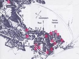
inner city-old road-Kalvarienberg-Malerwinkel- Hoffischergasse- inner cityduration about 50 min.
Starting place: 4801 Traunkirchen
Destination: 4801 Traunkirchen
duration: 0h 30m
length: 1,3 km
Altitude difference (uphill): 63m
Altitude difference (downhill): 29m
Lowest point: 426m
Highest point: 501m
difficulty: easy
condition: easy
panoramic view: Great panorama
Paths covering:
Gravel, Hiking trail
Starting point: inner city Traunkirchen
Destination: inner city Traunkirchen
further information:
- Flatly
- Possible accommodation
- Board possible
Accessibility / arrival
from the highway: departure Regau-in the direction of Bad Ischl-inner city Traunkirchen
- Suitable for groups
- Suitable for schools
- Pets allowed
- Spring
- Summer
- Autumn
- Early winter
Please get in touch for more information.
4801 Traunkirchen
Phone +43 7617 2234
E-Mail traunkirchen@traunsee.at
Web www.traunsee.at/traunkirchen
http://www.traunsee.at/traunkirchen
")
")
