Stubwieswipfel 1.786 m from the Wurzeralm
Path number: 218
Starting place: 4582 Spital am Pyhrn
Destination: 4582 Spital am Pyhrn
Stiftsplatz 1
4582 Spital am Pyhrn
4582 Spital am Pyhrn

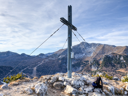
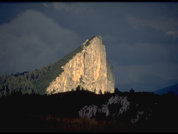
The Halfdome of the Wurzeralm - the wall of the Stubwieswipfel drops vertically to the southwest to the Wurzeralm. From the northwest, however, it can be climbed without any problems. At the summit you will be rewarded with a breathtaking view of the Wurzeralm and the Warscheneck-mountain range.
Tip: The Teichlboden deserves your special attention as the highest high moor in the Northern Limestone Alps. The Teichl, the watercourse running through this high moor, disappears underground during the so-called Teichlschwund. Be careful, you will pass it.
Path number: 218
Starting place: 4582 Spital am Pyhrn
Destination: 4582 Spital am Pyhrn
duration: 3h 0m
length: 6,4 km
Altitude difference (uphill): 493m
Altitude difference (downhill): 460m
Lowest point: 1.356m
Highest point: 1.739m
difficulty: medium
condition: medium
panoramic view: Great panorama
Paths covering:
Hiking trail
Starting point: Mountain station of the Wurzeralm funicular
Destination: Mountain station of the Wurzeralm funicular
further information:
- Possible accommodation
- Board possible
Accessibility / arrival
by car: Wurzeralm funicular valley station
environmentally friendly by bus: Line 911 from Spital or Windischgarsten train station
and from there ascent with the Wurzeralm funicular railway
Opening hours & prices
- Suitable for teenagers
- Suitable for seniors
- Suitable for single travelers
- Suitable for friends
- Suitable for couples
- Spring
- Summer
- Autumn
Please get in touch for more information.
Stiftsplatz 1
4582 Spital am Pyhrn
Phone +43 7563 249
Fax machine +43 7563 249 - 20
E-Mail spital@pyhrn-priel.net
Web www.urlaubsregion-pyhrn-priel.at/
https://www.urlaubsregion-pyhrn-priel.at/


