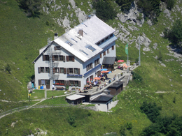
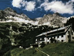
Prielschutzhaus
Path number: 201
Starting place: 4573 Hinterstoder
Destination: 4573 Hinterstoder

From the parking area of the Prielschutzhaus (1km after the village centre of Hinterstoder) you walk for about half an hour along a forest road passing the picturesque setting of the Schiederweiher to the transport cable car, where the actual start of the trail is situated.
Walk up many serpentines passing a waterfall, the big and small “oven“ (caves) to the „Thank-God-Bench“. Cross a ditch and continue through a wood cutting area to the fairy tale meadow. Further through a beech forest, partly close to the transport cable car over clearing to the Prielschutzhaus (managed from Easter to 26. October). The sunny terrace invites you to rest and enjoy the stunning alpine scenery.Return on the same trail. Trail-Nr: 201
Path number: 201
Starting place: 4573 Hinterstoder
Destination: 4573 Hinterstoder
duration: 3h 56m
length: 5,5 km
Altitude difference (uphill): 946m
Altitude difference (downhill): 103m
Lowest point: 612m
Highest point: 1.471m
difficulty: medium
condition: medium
panoramic view: Individual Views
Paths covering:
Gravel, Hiking trail
Starting point: Parking: Please the parking "Polsterlucke" (4573, Goierweg 21)
further information:
- Possible accommodation
- Board possible
Accessibility / arrival
Parking Polsterlucke (chargeable) from the Center of Hinterstoder just 3 km further on
to 6 hours € 4 6 bis 24 hours € 5 2 to max. 7 days € 10 Annual ticket € 30
Most economical season
- Spring
- Summer
- Autumn
Please get in touch for more information.
4573 Hinterstoder
Phone +43 7564 20602
mobile +43 699 17177080
E-Mail prielschutzhaus@gmx.at
Web www.prielschutzhaus.com/
https://www.prielschutzhaus.com/


