© Photo: Oberösterreich Tourismus GmbH./Robert Maybach: Enjoy the view in Upper Austria
Enjoy the view in Upper Austria
search
Search
Close

Dragon's walk

  • Flatly

 Interactive elevation profile

Download GPS data
Create PDF

Tour-Details

Path number: B
Starting place: 5310 St. Lorenz am Mondsee
Destination: 5310 St. Lorenz am Mondsee

duration: 7h 21m
length: 17,3 km
Altitude difference (uphill): 1.155m
Altitude difference (downhill): 1.148m

Lowest point: 488m
Highest point: 1.137m
difficulty: medium
condition: difficult
panoramic view: Great panorama

Paths covering:
Gravel

powered by TOURDATA

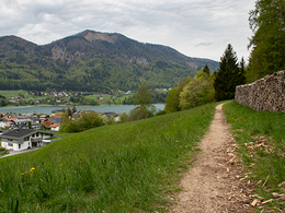
Longer Circular way, which is signed with a dragon.

The starting and finishing point of the app. 6-7 hours tour is the Gasthof "Drachenwand" in St. Lorenz (St. Lorenz 32, 5310 Mondsee, St. Lorenz. Tel: 43 6232 3356, opening times from May to September: Wednesday to Sunday from 9.am, in July and August also open on tuesday. All other times, reduced opening times).
From there the route travels south-east, after approx 50 m branch to the right. A sign indicates to the Theklakapelle. The route leads through the wood upwards. The signs are red-white-red. Keep to the left at ...
Travelling by public transport
Route planner for independent travellers
  • Suitable for single travelers
  • Suitable for friends
  • Suitable for couples
Most economical season
  • Spring
  • Summer
  • Autumn

Please get in touch for more information.


Dragon's walk
Tourismusverband Mondsee-Irrsee
Dr. Franz Müller Straße 3
5310 St. Lorenz am Mondsee

Phone +43 6232 2270
Fax machine +43 6232 2270 - 22
E-Mail info@mondsee.at
Web mondsee.salzkammergut.at
https://mondsee.salzkammergut.at

We speak the following languages

German

 Interactive elevation profile

Download GPS data
Create PDF

Tour-Details

Path number: B
Starting place: 5310 St. Lorenz am Mondsee
Destination: 5310 St. Lorenz am Mondsee

duration: 7h 21m
length: 17,3 km
Altitude difference (uphill): 1.155m
Altitude difference (downhill): 1.148m

Lowest point: 488m
Highest point: 1.137m
difficulty: medium
condition: difficult
panoramic view: Great panorama

Paths covering:
Gravel

powered by TOURDATA
Protected by