

St. Agatha: “Es muss sein” (“It has to be”) Trail


- Flatly
Interactive elevation profile
Create PDF
Tour-Details
Paths covering:
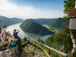
Hiking trail offering fantastic views of the Mühlviertel district, the foothills of the Alps and the Schlögen Danube Loop.
Recommended season:
- March
- April
- May
- June
- July
- August
- September
- October
- November
- Loop
- Scenic
- Refreshment stops available
- Geological highlights
From Kirchenplatz square we hike along Hauptstraße and take a right turn into Schulweg road. We hike past the secondary school and continue on a country lane. We hike northwards and get to Etzing, where there is also a Donausteig resting place. After Etzing we take a right turn and hike down towards the Danube. We leave the road at the last farm house and continue on a country lane and then through the forest down to Schlögen. We hike past Hotel Donauschlinge and up to Schlögener Blick vantage point. Then we continue on Ciconia Trail for a bit. We follow Donausteig Trail until we leave Haibach. In the Donauleiten hills we take a turn towards Wiesing and after a downhill section we cross the Nibelungen federal road. On the other side of the road we hike uphill again on a ski piste. We leave the forest at Dunzing and continue to hike through the cultured landscape. We pass the Fadinger monument and two guesthouses before we get back to St. Agatha.Directions:
Vom Kirchenplatz wandern wir die Hauptstraße entlang und biegen rechts in den Schulweg ein. Vorbei an der Hauptschule geht es über einen Feldweg weiter. Wir halten uns weiter in Richtung Norden und gelangen nach Etzing, wo sich auch ein Donausteigrastplatz befindet. Nach Etzing biegen wir rechts ab und wandern nach unten Richtung Donau. Beim letzten Bauernhof verlassen wir die Straße und gehen erst über einen Feldweg, dann durch den Wald hinunter nach Schlögen. Vorbei am Hotel Donauschlinge wandern wir den Weg hinauf zum Schlögener Blick und folgen danach ein Stück dem Ciconia Weg. Bis nach Haibach folgen wir dem Verlauf des Donausteiges. In den Donauleiten biegen wir aber Richtung Wiesing ab und queren nach einem Abstieg die Nibelungen Bundesstraße. Auf der anderen Seite steigen wir vorbei an einer Schipiste wieder auf. Wir folgen dem Wanderweg, gehen aber nicht bis zur Ruine Stauff, sonder biegen vorher rechts ab. Bei Dunzing verlassen wir den Wald und wandern sodann wieder durch die Kulturlandschaft. Wir kommen am Fadingerdenkmal und zwei Wirtshäusern vorbei, bevor wir wieder in St. Agatha ankommen.
Tip:
Fantastic view of the Mühlviertel district and the foothills of the Alps
Equipment:
Standard hiking equipmentAdditional information:
4084 St. Agatha, Kirchenplatz 1
Tel.: 0043(0)07277/8255-15 Fax: 0043(0)7277/8255-15
E-mail: info.st-agatha@upperaustria.or.at
www.tiscover.com/st.agatha
further information:
- Flatly
- Board possible


")


")
")
")
")
")
")
")
")
Getting there
By car:
... from Passau: take “Passau-Nord” or “Passau-Mitte” autobahn exit, toll free on Nibelungenstraße, B130 (approx. 40km);
... from Linz: toll free on the B129 past Eferding (B130);
... from Wels: toll free on the B137 or B134 past Eferding (B130);
St. Agatha is located at the southern bank of the Danube.
By train:
... past Passau - Neumarkt - Grieskirchen - Linz;
The nearest train station is in Waizenkirchen (7km).
www.oebb.at
By boat:
... on the Danube: from Passau - Schlögen or Linz - Schlögen (Wurm + Köck shipping company)
www.donauschiffahrt.de
Public Transit
Bus: www.postbus.at
Parking
Municipality of St. Agatha
- Spring
- Summer
- Autumn
- Early winter
Please get in touch for more information.
Kirchenplatz 1
4083 St. Agatha
Phone +43 7277 8255 - 0
E-Mail info.st-agatha@oberoesterreich.at
Web tourismus.st-agatha.at
Web www.st-agatha.at
http://www.st-agatha.at
Interactive elevation profile
Create PDF
Tour-Details
Paths covering: