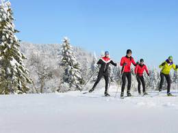
© Foto Oberösterreich Tourismus GmbH/Robert Maybach: Beim Wandern auf der Höss in Hinterstoder den Ausblick genießen.
Anbindungsloipe Leopoldschlag bis Rainbach


- pets allowed
- culinary interesting
- Possible accommodation
Interactive elevation profile
Create PDF
Tour-Details
Starting place: 4262 Leopoldschlag
Destination: 4261 Rainbach im Mühlkreis
duration: 0h 45m
length: 4,2 km
Altitude difference (uphill): 82m
Altitude difference (downhill): 9m
Lowest point: 627m
Highest point: 713m
difficulty: easy
condition: medium
panoramic view: Individual Views
Paths covering:
snow
powered by TOURDATA
Trail not in operation
The trail connects two cross-country skiing locations!
Both beginners and cross-country skiing pros can enjoy cross-country skiing on trails of various lengths.
Information on the current cross-country ski trail situation is available from the Leopoldschlag municipal office: +43 (0)7949/8255-10
Starting point: Fire station Coordinates to the entry point: Lat: 48.61570414168777 Longitude: 14.500247240066528
Destination: Kerschbaum
further information:
- culinary interesting
- Possible accommodation
- Board possible
Details - Trail
- Nordic skiing facilities: Marked Nordic skiing run
- Type of Nordic skiing run: Classic style
- free
with suitable snow conditions.
Accessibility / arrival
by car:
from Linz: via the A7 motorway to Unterweitersdorf, continue on the S10 (Mühlviertler Schnellstraße) exit Freistadt Nord, continue on the B310 to Leopoldschlag
by train:
from Linz: Summerauerbahn to Summerau station --> 10 km to Leopoldschlag
- Parking space: 5
General price information
Voluntary donations to cover the costs
- Suitable for groups
- Pets allowed
- Suitable for teenagers
- Suitable for seniors
- Suitable for single travelers
- Suitable for friends
- Suitable for couples
- Deep winter
Please get in touch for more information.
Marktplatz 17
4262 Leopoldschlag
Phone +43 7949 8255
E-Mail gemeinde@leopoldschlag.ooe.gv.at
Web www.leopoldschlag.ooe.gv.at/
Web www.muehlviertel-almfreistadt.at/wa…
http://www.leopoldschlag.ooe.gv.at/
https://www.muehlviertel-almfreistadt.at/was-moechten-sie-erleben/winter/langlaufen-schneeschuhwandern.html
https://www.muehlviertel-almfreistadt.at/was-moechten-sie-erleben/winter/langlaufen-schneeschuhwandern.html
Interactive elevation profile
Create PDF
Tour-Details
Starting place: 4262 Leopoldschlag
Destination: 4261 Rainbach im Mühlkreis
duration: 0h 45m
length: 4,2 km
Altitude difference (uphill): 82m
Altitude difference (downhill): 9m
Lowest point: 627m
Highest point: 713m
difficulty: easy
condition: medium
panoramic view: Individual Views
Paths covering:
snow
powered by TOURDATA
