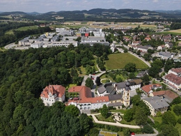
Architecture walk Hagenberg
Starting place: 4232 Hagenberg im Mühlkreis
Destination: 4232 Hagenberg im Mühlkreis
Kirchenplatz 5a
4232 Hagenberg im Mühlkreis
4232 Hagenberg im Mühlkreis

Architecture combines old and new.
For years, Hagenberg has served as a successful example of careful
architecture in rural areas.
The mill was rebuilt as faithfully as possible to the original. The University of Applied Sciences
Hagenberg is a highlight of modern architecture in the style of traditional
rural buildings. The new building is particularly impressive due to its
"square" design. The traditional shape gives the building a strong identity. The amsec building shines with
modern architecture, a promising headquarters
for softwarenahe companies. Also impressive is the so-called Neue Mitte
- the business and infrastructure centre of Hagenberg.
The architectural guide to Hagenberg - available from the municipal office - provides an in-depth look at the architectural considerations and details of the design.
Starting place: 4232 Hagenberg im Mühlkreis
Destination: 4232 Hagenberg im Mühlkreis
duration: 0h 36m
length: 2,3 km
Altitude difference (uphill): 28m
Altitude difference (downhill): 22m
Lowest point: 440m
Highest point: 468m
difficulty: very easy
condition: very easy
panoramic view: No view
Paths covering:
Asphalt, Street, Other
Starting point: Hagenberg Castle
Destination: Hagenberg Castle
Most economical season
- Spring
- Autumn
- Early winter
Please get in touch for more information.
Kirchenplatz 5a
4232 Hagenberg im Mühlkreis
Phone +43 7236 2318
E-Mail anfrage@muehlviertel.at
Web www.hagenberg.at/
Web www.muehlviertel-urlaub.at/wandern
https://www.hagenberg.at/
https://www.muehlviertel-urlaub.at/wandern
https://www.muehlviertel-urlaub.at/wandern


