P6 Unteres Feldaisttal
Path number: P6
Starting place: 4230 Pregarten
Destination: 4230 Pregarten

From the church square, walk in a westerly direction, cross the town square, go through the passage next to the town hall, cross the car park and turn right on the path over the railway bridge to the station;
Shortly afterwards, just before the bypass, turn left into the Feldaisttal valley. Passing the Teufelsmauer you reach the Klausmühle. Following the course of the river, you walk further downstream in the protected landscape area, past the Georgibründl, the Notmühle and the Jungfernsprung. You then cross the river on the Jahnsteg footbridge. The entire trail offers a beautiful view of the rock-strewn riverbed, squeezed into sometimes very steep rock formations. You pass glacier mills and a climbing garden. The path then continues through a crevice and a little later over a bridge. It is definitely worth making a detour to the Kriehmühle mill (approx. 1 hour), which offers a good place to stop for refreshments. Continue along the right bank of the river to the next bridge. (Option to continue to the Felsensteinerkreuz on W 3). Otherwise cross the Aist, branch off to the left shortly afterwards and walk via the "Bauer zu Aist" and Silberbach, Althauser Straße and Bindergasse back to the town.Nature is always there for us. It is only fair that we are there for nature too.
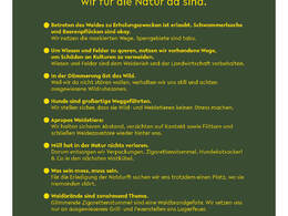
Please follow the fair play rules for hiking!
Path number: P6
Starting place: 4230 Pregarten
Destination: 4230 Pregarten
duration: 3h 21m
length: 12,3 km
Altitude difference (uphill): 186m
Altitude difference (downhill): 190m
Lowest point: 325m
Highest point: 427m
difficulty: medium
condition: medium
panoramic view: Individual Views
Paths covering:
Asphalt, Hiking trail
Starting point: Pregarten town square
Destination: Pregarten town square
further information:
- Flatly
- Board possible
Accessibility / arrival
Coming from Linz:
Take the A7 motorway towards Freistadt as far as Unterweitersdorf. From there, take the B124 towards Pregarten and Tragwein as far as the Pregarten town centre exit.
- Free entry
- All weather
- Suitable for groups
- Suitable for schools
- Suitable for teenagers
- Suitable for seniors
- Suitable for single travelers
- Suitable for families
- Suitable for friends
- Suitable for couples
- Suitable for children
- Spring
- Summer
- Autumn
- Early winter
Please get in touch for more information.
4230 Pregarten
Phone +43 7236 2255
E-Mail Stadtamt@pregarten.ooe.gv.at
Web www.pregarten.at/
https://www.pregarten.at/


