Beer bike tour - "Panorama South"
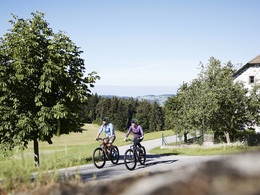


 Bruno Haneder | © Bruno Haneder")
 Bruno Haneder | © Bruno Haneder")
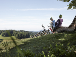
 Bruno Haneder | © Bruno Haneder")
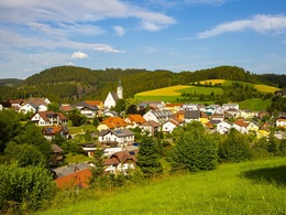
 Pabneukirchen | © Gemeinde Pabneukirchen")
 Pabneukirchen | © Gemeinde Pabneukirchen")
4283 Bad Zell

Description: NOTE:
Due to sustainability, the tour is NOT signposted! You can navigate the tour using the GPS data (only in one direction), which you can download HERE effortlessly. The tour is also shown on our cycle map "Cycling in the hills".
On the "Panorama South" beer bike tour , you can enjoy unique panoramic views of the Mühlviertler Alm Freistadt holiday region and the Waldviertel to the full. Cycle the north tour one day and the south tour the next.
Total south & north tour: 104 km, riding time approx. 8 hours ↑ 2,060 m ↓ 2,050 m altitude difference
Panorama South : 50 km, travelling time approx. 4 hours ↑ 1,100 m ↓ 1,090 m altitude difference
Panorama North: 54 km, travelling time approx. 4 hours ↑ 960 m ↓ 960 m altitude difference
Stage for the day
Königswiesen - St. Georgen am Walde - Pabneukirchen - Mönchdorf - Königswiesen
Starting point is Königswiesen
Public car park in the town centre
Parking facilities
Car park opposite Raiffeisenbank, commuter car park opposite the warehouse
and at the outdoor pool in Königswiesen
Overnight accommodation
You can find all accommodation options on our website www.muehlviertel-urlaub.at
All cycle-related information and stage suggestions can be found atMultimedia/Documents
to the full. The cycle tour leads to unique vantage points such as the summit cross in Königswiesen, the ruins in Arbesbach and below the summit of the Kranzberg in St. Georgen/W..
This idyllic but challenging route is rewarded with marvellous panoramic views
over the Waldviertel, the Ötscher, the Dachstein and the Bohemian Forest.
Natural jewels such as the almost unspoilt Tannermoor and the Rubner Teich pond invite you to linger and recharge your batteries.
invite you to linger and recharge your batteries. The tour reflects the beauty of the
Mühlviertel and Waldviertel in all its uniqueness and unspoilt beauty.
Panorama highlights on the tour
Königswiesen: Harlingsedt summit cross at 920 metres above sea level with magnificent views as far as
to the Bohemian Forest, Ötscher, Dachstein and the Waldviertel. Pabneukirchen: Typical
Mühlviertel hilly landscape with varied cycle paths. Mönchdorf:
Natural monument Bücherstein, whose shape is reminiscent of books on a shelf.
Beer tip
- Braugasthof Sengstbratl (home-brewed beer), St. Georgen am Walde
- Lind'n Bräu brewery, St. Georgen am Walde
Route
Start in Königswiesen (public car park in the town centre) - head towards the B124 (on the R5 cycle path) then turn left onto Zwettler Straße towards Haid - after approx. 1 km turn right onto Herzogweg towards Altmelon (Lower Austria) via Paroxedt or Stiftinger Wald - after approx. 4 km you come to a crossroads - turn right here onto the Tour de Alm M4 mountain bike route (forest path) - after approx. 3 km turn right (steep ascent) and cycle approx. 14 km on cycle path no. 962 (NOTE: If you want an easier start in Königswiesen, you can follow cycle path no. 962 to Ottenschlag) through the villages of Ottenschlag, St. Georgen am Walde and through Untert. Georgen am Walde and through Unter St. Georgen to Großerlau, where you leave cycle path no. 962 to the left towards Oberreisendorf - after approx. 2 km turn right towards Pabneukirchen and after approx. 6 km you reach Pabneukirchen - here you follow the course of the main road and turn left at the Lionfit fitness centre towards Mönchdorf - you pass below the Wetzelsberg and through dust after approx. 4 km you come to a junction where you keep right and cycle along Greinerwaldstraße for approx. 2 km to Mönchdorf Ort. Here you pass the Moser Alm - here you turn left onto the B124 and after 700 m turn left again to the Ebrixmühle - you reach this after approx. 600 m where you turn right towards Mötlas past the Wahlmüller inn "Wirt in Mötlas" and below the Ebenlussberg (approx. 6 km) - from here you turn right onto the cycle path 942 towards Königswiesen (past the Wackelstein) and after approx. 6 km you reach Königswiesen again.
Paths covering:
further information:
- Flatly
- Possible accommodation
- Experience of nature
- Board possible
)")
")
")
")
")


- Suitable for seniors
- Suitable for single travelers
- Suitable for friends
- Suitable for couples
- Spring
- Summer
- Autumn
Please get in touch for more information.
")
Lebensquellplatz 1
4283 Bad Zell
Phone +43 5 07263 - 301
E-Mail badzell@muehlviertel.at
Web www.muehlviertel.at
")
")
")
")


")
")
")


")

")
")

_Verein_Schorschi (© Verein Schorschi)")
")
")
")
")