

Nativity Trail - longer Circuit


- pets allowed
- All weather
- Suitable for families
- Suitable for pushchairs
- Suitable for kids (all ages)
- culturally interesting
- Flatly
Interactive elevation profile
Create PDF
Tour-Details
Starting place: 4682 Geboltskirchen
Destination: 4682 Geboltskirchen
duration: 0h 24m
length: 1,6 km
Altitude difference (uphill): 19m
Altitude difference (downhill): 19m
Lowest point: 530m
Highest point: 549m
difficulty: easy
condition: medium
panoramic view: Individual Views
Paths covering:
Asphalt, Other
powered by TOURDATA
Approx. 2,5 km
6 stations
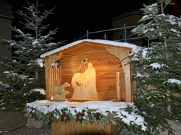
Hiking trail with chapel around the village
You are guaranteed to get into the pre-Christmas spirit in Geboltskirchen. From the first weekend of Advent, the Nativity Scene Trail is waiting to be walked. The 2.5 kilometer long circular route starts from the Catholic parish church.
The long circular walk can also be combined with the crib walk.
6 stations
Hiking trail with chapel around the village
You are guaranteed to get into the pre-Christmas spirit in Geboltskirchen. From the first weekend of Advent, the Nativity Scene Trail is waiting to be walked. The 2.5 kilometer long circular route starts from the Catholic parish church.
The long circular walk can also be combined with the crib walk.
1. Krippe im Holzfass
2. Stricker Kapelle
3. Öhlerkapelle
4. Langauer Kapelle
5. Hochradmühle
6. Pfarrheim

Accessibility / arrival
Ölerhaus - Spitz 15, 4682 Geboltskirchen
You will find parking spaces directly in front of the house, at the church or the municipal office
free of charge
- Free entry
- All weather
- Suitable for kids (all ages)
- Suitable for pushchairs
- Pets allowed
- Suitable for seniors
- Suitable for friends
- Suitable for couples
- Suitable for children
- Early winter
- Deep winter
Suitable for wheelchairs: Not all of the legally stipulated ÖNORM are complied with. In principle, this object is suitable for wheelchairs and no assistance is necessary.
4682 Geboltskirchen
mobile +43 664 8548192
E-Mail info@vitalwelt.at
Web www.vitalwelt.at
https://www.vitalwelt.at
Interactive elevation profile
Create PDF
Tour-Details
Starting place: 4682 Geboltskirchen
Destination: 4682 Geboltskirchen
duration: 0h 24m
length: 1,6 km
Altitude difference (uphill): 19m
Altitude difference (downhill): 19m
Lowest point: 530m
Highest point: 549m
difficulty: easy
condition: medium
panoramic view: Individual Views
Paths covering:
Asphalt, Other
powered by TOURDATA