Rennradhügelwelt Mühlviertel - "Braucommune Freistadt Tour"


4283 Bad Zell

Description: The navigation of the road bike route "Braucommune Freistadt Tour" is only prepared digitally. You can easily download the GPS file on this page
In addition, the tour is also presented in our free A3 flyer .
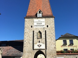
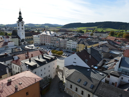
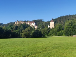
The starting point and first highlight of this tour is the town square of the medieval district capital of Freistadt. From here, you follow in the footsteps of the first stage of the 2019 Tour of Austria to Lasberg. The tour continues over two challenging climbs to St. Leonhard bei Freistadt. After a long descent, the route leads through the Aisttal valley to the ruins of Reichenstein Castle, mostly with a slight gradient. At the beginning of the last third of the tour, there is a long climb to conquer. You then cycle back to the starting point in Freistadt on very well-maintained roads.
Cycle path: 1.48 km
Secondary road: 3.72 km
Road: 67.8 km
Main road: 6.13 km
Road condition:
Road surface: 22.8 km
Asphalt: 54.4 km
Car parking facilities:
- Scheiblingturm car park
- Car park in St. Peterstraße
Repair facilities:
- Intersport Pötscher in Freistadt
- Radsport Fischerlehner in Freistadt
- Rotschne company in Freistadt
- Guesthouse Weitblick in St. Leonhard near Freistadt
Paths covering:
further information:
- Flatly
- Possible accommodation
- Board possible
")
")
")

- Suitable for single travelers
- Suitable for friends
- Spring
- Summer
- Autumn
Please get in touch for more information.
")
Lebensquellplatz 1
4283 Bad Zell
Phone +43 5 07263 - 301
E-Mail badzell@muehlviertel.at
Web www.muehlviertel.at

")

")
patriciakoppenberger-9157 (© Hotel zum Goldenen Hirsch/Koppenberger)")
")
")
")
")


")
")
")
")
")