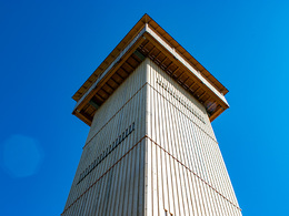
Via the forest road to the Kulmspitz lookout tower
Starting place: 5310 Innerschwand am Mondsee
Destination: 5310 Innerschwand am Mondsee
Dr. Franz Müller Str. 3
5311 Innerschwand am Mondsee
5311 Innerschwand am Mondsee

Family-friendly, easy hike with a great panorama from the Kulmspitz lookout tower.
From the hiking car park in Stabau we pass the barriers and then walk straight on along the forest road. After a while, the forest road turns. Here we keep left and continue to follow the forest road slightly uphill to the Kulmspitz lookout tower.
Accessibility / arrival
From Mondsee towards Mondseeberg. Under the highway bridge and on to a hairpin bend. At the steep curve turn right and continue driving to the direction of "Stabau". Now always follow the road to Stabau and drive to its end. The Stabau hiking parking lot is located here.
- Parking space: 10
none
- Suitable for groups
- Suitable for schools
- Suitable for kids (all ages)
- Suitable for pushchairs
- Suitable for teenagers
- Suitable for seniors
- Suitable for single travelers
- Suitable for families
- Suitable for friends
- Suitable for couples
- Suitable for children
- Spring
- Summer
- Autumn
Somewhat suitable for wheelchairs: Assistance is sometimes necessary. The measurements do not (fully) conform to the legally stipulated ÖNORM.
Dr. Franz Müller Str. 3
5311 Innerschwand am Mondsee
Phone +43 6232 2270
Fax machine +43 6232 2270 - 22
E-Mail info@mondsee.at
Web mondsee.salzkammergut.at/
https://mondsee.salzkammergut.at/


