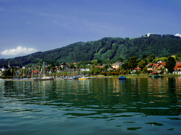
© Photo: Oberösterreich Tourismus GmbH./Robert Maybach: Enjoy the view in Upper Austria
Enjoy the view in Upper Austria
Search
Search
Close

RUNNERSFUN Runde by Runnersfun

 Interactive elevation profile

Download GPS data
Create PDF

Tour-Details

Starting place: 4813 Altmünster
Destination: 4813 Altmünster

duration: 3h 11m
length: 10,2 km
Altitude difference (uphill): 334m
Altitude difference (downhill): 328m

Lowest point: 427m
Highest point: 743m
difficulty: difficult
condition: difficult
panoramic view: Individual Views

Paths covering:
Asphalt

powered by TOURDATA

Altmünster exercise arena - RUNNERSFUN round - red The "Runnersfun circuit" is perfect for anyone who wants to really burn off energy. After the start on the Esplanade lakeside promenade, the challenging training circuit first leads along Marktstraße, then follows the signposts through wooded areas of nature and forest trails. The route then climbs steadily towards Grasberg, past the Reschenweirt inn and back to the starting point via Staudachstraße. Suitable for fit and experienced runners and walkers, but can also be managed by everyone at a slower pace.
Travelling by public transport
Route planner for independent travellers
Most economical season
  • Spring
  • Summer
  • Autumn
  • Early winter
  • Deep winter

Please get in touch for more information.


RUNNERSFUN Runde by Runnersfun
Runnersfun Consulting GmbH Bewegung erleben
Krottenseestraße 45
4810 Gmunden

Phone +43 7612 20822
E-Mail office@runnersfun.com
Web www.runnersfun.com/
http://www.runnersfun.com/

We speak the following languages

German

 Interactive elevation profile

Download GPS data
Create PDF

Tour-Details

Starting place: 4813 Altmünster
Destination: 4813 Altmünster

duration: 3h 11m
length: 10,2 km
Altitude difference (uphill): 334m
Altitude difference (downhill): 328m

Lowest point: 427m
Highest point: 743m
difficulty: difficult
condition: difficult
panoramic view: Individual Views

Paths covering:
Asphalt

powered by TOURDATA