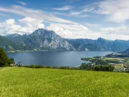
© Photo: Oberösterreich Tourismus GmbH./Robert Maybach: Enjoy the view in Upper Austria
Enjoy the view in Upper Austria
search
Search
Close

ENJOYMENT from lake to lake, along the rivers TRAUN and ALM - from lake Traunsee to lake Almsee

  • All weather
  • culinary interesting
  • culturally interesting
  • Multi-day tour
  • Possible accommodation

 Interactive elevation profile

Download GPS data
Create PDF

Tour-Details

Starting place: 4810 Gmunden
Destination: 4645 Grünau im Almtal

duration: 9h 13m
length: 36,3 km
Altitude difference (uphill): 272m
Altitude difference (downhill): 209m

Lowest point: 333m
Highest point: 447m
difficulty: easy
condition: medium
panoramic view: Great panorama

Paths covering:
Asphalt, Gravel, Hiking trail, Other

powered by TOURDATA

From lake to lake!
The hiking trail from Gmunden along the Traunuferweg via the Almspitz further along the Alm river path to the lake Almsee.

Accessibility / arrival

Arrival by train to Bad Wimsbach-Neydharting, also possible by car.

Parking
  • Parking space: 10
Travelling by public transport
Route planner for independent travellers
  • All weather
  • Suitable for groups
  • Suitable for teenagers
  • Suitable for seniors
  • Suitable for friends
  • Suitable for couples
Most economical season
  • Spring
  • Summer
  • Autumn

Please get in touch for more information.


ENJOYMENT from lake to lake, along the rivers TRAUN and ALM - from lake Traunsee to lake Almsee
Tourismusverband Traunsee-Almtal - Salzkammergut / Büro Almtal
Im Dorf 17
4645 Grünau im Almtal

Phone +43 7616 8268
mobile +43 7612 74451
E-Mail info@traunsee-almtal.at
Web www.traunsee-almtal.at
Web www.wander-spass.at
https://www.traunsee-almtal.at
http://www.wander-spass.at

We speak the following languages

German
English

 Interactive elevation profile

Download GPS data
Create PDF

Tour-Details

Starting place: 4810 Gmunden
Destination: 4645 Grünau im Almtal

duration: 9h 13m
length: 36,3 km
Altitude difference (uphill): 272m
Altitude difference (downhill): 209m

Lowest point: 333m
Highest point: 447m
difficulty: easy
condition: medium
panoramic view: Great panorama

Paths covering:
Asphalt, Gravel, Hiking trail, Other

powered by TOURDATA