Waldluftbadeweg Greisinghof
Path number: Route mit grünen Legenden
Starting place: 4284 Tragwein
Destination: 4284 Tragwein
Markt 33
4284 Tragwein
4284 Tragwein

Forest air bathing in Tragwein
Tragwein is located in the Aist-Naarn-Kuppenland. The landscape is characterised by strongly structured mountain and hill country with numerous hilltops and narrow valley sections. There are rocky outcrops in the forests and remnants of original stone block meadows. The Weinsberg granite gives the landscape an uneven character with rapid changes between hilltops and valleys and has a high block-forming power. The centre of the landscape organism is the Gruberberg (698 m) in the north.
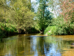
The route leads from the centre of Tragwein through the Badgraben to a radon spring that has been known since the 16th century. The route continues along the Lungitzbach stream through the Lungitzer-Graben. Around the middle of the hike, you can take a detour to the north to a good airfield.
Continue straight on via Mistlberg to the Greisinghof. The Greisinghof was probably built in the late Middle Ages as a farmstead for the Greising estate. Today, it houses a monastery and seminar centre of the Marianist Order. There are several beautiful circular trails around the Greisinghof: the water trail including the Himmelsstiege, the Kirchensteig and the Höhenweg. The Greisinghof also offers further opportunities for forest air bathing.
After the Greisinghof, we follow the forest air bathing tour northwards towards Reichenstein. Near the crossing of the Mörtenbergerbach stream, we turn east towards Zudersdorf. Alternatively, a detour to Reichenstein is also possible. From Zudersdorf, the T2/T11 hiking trail leads back to Tragwein.
Greisinghof forest air bathing trail - waypoints
1. hiking stone
2nd radon spring, fountain and bath
3rd Mistlberg airfield
4th Greisinghof
5. return hike Tragwein or
6. detour to Reichenstein
For guided tours, please contact our qualified forest air bath attendants - you can find more information here.
Path number: Route mit grünen Legenden
Starting place: 4284 Tragwein
Destination: 4284 Tragwein
duration: 3h 49m
length: 12,9 km
Altitude difference (uphill): 332m
Altitude difference (downhill): 336m
Lowest point: 337m
Highest point: 576m
difficulty: easy
condition: easy
panoramic view: Some Views
Paths covering:
Asphalt, Hiking trail, Other
Starting point: Wanderstein town center Tragwein
Destination: Reichenstein or Wanderstein town centre Tragwein
further information:
- Flatly
Details - hiking
- themed path
- All weather
- Suitable for groups
- Suitable for schools
- Suitable for teenagers
- Suitable for seniors
- Suitable for single travelers
- Suitable for families
- Suitable for friends
- Suitable for couples
- Spring
- Summer
- Autumn
Please get in touch for more information.
Markt 33
4284 Tragwein
Phone +43 7263 88255
E-Mail freistadt@muehlviertel.at
Web www.waldluftbaden.at
https://www.waldluftbaden.at


