Weg Großdöllnerhof
Path number: 5
Starting place: 4324 Rechberg
Destination: 4324 Rechberg
Rechberg 9
4324 Rechberg
4324 Rechberg

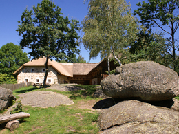
The short hiking trail leads to the Großdöllnerhof and can be ideally combined with a visit to the open-air museum.
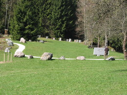
Starting point is the village square. Along the road to the bathing lake. From here, a forest path leads to the Steinwiese and the Großdöllnerhof.Opening times of the open-air museum:
May, June, September and October on Saturdays, Sundays and public holidays from 1 pm to 6 pm
July and August every Sunday and public holiday from 1 pm to 6 pm
Path number: 5
Starting place: 4324 Rechberg
Destination: 4324 Rechberg
duration: 0h 27m
length: 1,3 km
Altitude difference (uphill): 78m
Lowest point: 578m
Highest point: 656m
difficulty: very easy
condition: easy
panoramic view: Individual Views
Paths covering:
Asphalt, unfixed, Hiking trail
Starting point: Rechberg village square
Destination: Großdöllnerhof Rechberg
further information:
Accessibility / arrival
A1 from Salzburg - exit Asten/St. Florian - Mauthausen - Perg - Naarntalstraße to Rechberg.
A1 from Vienna - exit Ybbs - Grein - Klam - Münzbach - Rechberg
- Charging point for electric cars (free of charge)
- Charging point for e-bikes (free of charge)
- Free entry
- All weather
- Suitable for groups
- Suitable for schools
- Suitable for kids (all ages)
- Pets allowed
- Suitable for teenagers
- Suitable for seniors
- Suitable for single travelers
- Suitable for families
- Suitable for friends
- Suitable for couples
- Suitable for children
- Spring
- Summer
- Autumn
- Early winter
Not suitable for wheelchairs. The property is not compliant with Austria's ÖNORM legal standard.
Rechberg 9
4324 Rechberg
Phone +43 7264 4655
E-Mail gemeindeamt@rechberg.ooe.gv.at
Web www.rechberg.at/
https://www.rechberg.at/


