

Große 4-Seen-Runde


- Flatly
Interactive elevation profile
Create PDF
Tour-Details
Starting place: 4810 Gmunden
Destination: 4810 Gmunden
duration: 3h 51m
length: 213,7 km
Altitude difference (uphill): 3.027m
Altitude difference (downhill): 3.012m
Lowest point: 399m
Highest point: 1.002m
difficulty: difficult
condition: very difficult
panoramic view: Great panorama
Paths covering:
Asphalt
powered by TOURDATA
roadblock: Lessern: Sperre Wegabschnitt Naturlehrpfad
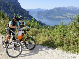
since 21.06.2023 Follow us along the 4 beautiful lakes in the Salzkammergut - Altausseer See, Grundlsee, Hallstätter See and Traunsee The circular tour leads from Gmunden via Gschwandt and Vorchdorf, continuing via Kirchdorf past Micheldorf along the Pyhrnpass road. Follow the Pyhrnpass road to Bad Aussee, Bad Ischl and along Lake Traunsee back to Gmunden.
This is one of the more challenging of the many lake tours in the Salzkammergut. It is also brilliant because swimming trunks (strapped to the handlebars) are compulsory equipment. Lake Altaussee, Lake Grundlsee, Lake Hallstättersee and Lake Traunsee also need to be used.
This is one of the more challenging of the many lake tours in the Salzkammergut. It is also brilliant because swimming trunks (strapped to the handlebars) are compulsory equipment. Lake Altaussee, Lake Grundlsee, Lake Hallstättersee and Lake Traunsee also need to be used.
Parking
- Parking space: 250
- Parking area for disabled: 2
- Bus parking space: 5
- Suitable for single travelers
- Suitable for friends
- Suitable for couples
- Spring
- Summer
Please get in touch for more information.
Toscanapark 1
4810 Gmunden
Phone +43 7612 74451
Fax machine +43 7612 71410
E-Mail info@traunsee-almtal.at
Web traunsee-almtal.salzkammergut.at/
https://traunsee-almtal.salzkammergut.at/
Interactive elevation profile
Create PDF
Tour-Details
Starting place: 4810 Gmunden
Destination: 4810 Gmunden
duration: 3h 51m
length: 213,7 km
Altitude difference (uphill): 3.027m
Altitude difference (downhill): 3.012m
Lowest point: 399m
Highest point: 1.002m
difficulty: difficult
condition: very difficult
panoramic view: Great panorama
Paths covering:
Asphalt
powered by TOURDATA