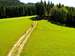
Taiskirchner Wanderweg
Starting place: 4753 Taiskirchen im Innkreis
Destination: 4753 Taiskirchen im Innkreis
Brief description:
The Taiskirchen cycling and hiking trail has a total length of approx. 33 km and leads from the Fit-Treff route towards Fischmarkt, past the Kapuzinerbankerl, to Altmannsdorf to the retention basin, to Arling, Helfingsdorf, Hohenerlach, Unterbreitenried, Wohleiten, Flohleiten, Edtleiten, via Tiefenbach past the Wetterkreuz, to Ellerbach, Wiesenberg, Brandstätten, Jedretsberg, Zahra, Wolfsedt, and back to the Fit-Treff car park.
Taiskirchen (Fit-Treff car park) - Altmannsdorf - Arling - Helfingsdorf - Hohenerlach - Unterbreitenried - Wohleiten - Flohleiten - Edtleiten - Tiefenbach - Ellerbach - Wiesenberg - Brandstätten - Jedretsberg - Zahra - Wolfsedt - Taiskirchen (Fit-Treff car park)
Description:
Several shrines and chapels are located directly on the cycle path.
At the Kapuzinerbankerl is the Kapuzinermarterl. At this point you can also enjoy a wonderful view of the Hochficht (Bohemian Forest), the municipalities of St. Roman, Kopfing, St. Willibald, Altschwendt, Riedau, Dorf an der Pram, Kallham, Pram, the Schulterberg in Pram, the municipality of Haag am Hausruck, the Pöstlingberg (Linz) and even the Frauenstein (Molln).
The Altmann Chapel and the reservoir chapel are located in Altmannsdorf.
Reservoir (retention basin) in Altmannsdorf:
Between 1980 and 1984, the Pramtal water board built a retention basin on the Pram. With the participation of the 3 neighbouring communities of Taiskirchen, Pram and Dorf an der Pram, a 7-hectare ground lake was constructed, an island was provided, bathing jetties were installed and a sunbathing lawn was built.
The reservoir is used by young people and adults alike; in summer for camping, barbecues and fishing, in winter for curling or ice skating.
The Rotzaunkreuz and the Wetterkreuz can be found in Edtleiten.
The weather cross was erected by the surrounding residents in 1869 due to the very strong thunderstorms and storms and is a striking sight with a height of approx. 5 metres. Christ's instruments of suffering are depicted on the weather cross.
The weather cross was renovated in 1925 and 1962, and in 1967 the sweat cloth of Jesus Christ was impressively carved out of oak wood by machinist Johann Unfried and added to the weather cross.
The Ellerberg cross and the Machtla cross are also located on the cycle route in Ellerbach.
Further along the route are the Wiesenberger Chapel (built in 1894) and the Gaderbauern Column in Wiesenberg, the Günzing Cross and the Binderhiasl Chapel in Günzing, the Loiprecht Chapel (built in 1905, with a Lourdes grotto) in Bruckleiten, the Reinthaler Chapel and the Brandstättner Chapel (built in 1904) in Zahra and the 5 metre high Gumpinger Cross in Wolfsedt. The Gumpingerkreuz shows Jesus on the cross and Mary. The cross was erected in 1875 following two major farm fires.
- Suitable for groups
- Suitable for kids (7 - 14 Year)
- Pets allowed
- Suitable for teenagers
- Suitable for seniors
- Suitable for single travelers
- Suitable for families
- Suitable for friends
- Suitable for couples
- Suitable for children
- Spring
- Summer
- Autumn
Please get in touch for more information.
Hofmarkt 29
4753 Taiskirchen im Innkreis
Phone +43 7764 8257
Fax machine +43 7764 8257 - 15
E-Mail gemeinde@taiskirchen.ooe.gv.at
Web www.taiskirchen.at
http://www.taiskirchen.at


