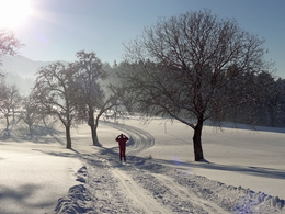
Chapel cross country ski trail
Starting place: 4865 Nußdorf am Attersee
Destination: 4865 Nußdorf am Attersee
Not in operation
Enjoy nature to the fullest on a length of 5 km the snowy winter landscape, in the region Attersee-Attergau between Nußdorf and Oberwang.
If you don't have cross-country skis and boots, you can rent them at a reasonable price at the Waldfrieden Inn - here you can also get up-to-date information about the trails and snow conditions.
Snow telephone +43 (0) 6233 8330
Starting place: 4865 Nußdorf am Attersee
Destination: 4865 Nußdorf am Attersee
duration: 0h 52m
length: 2,8 km
Altitude difference (uphill): 84m
Altitude difference (downhill): 83m
Highest point: 788m
difficulty: medium
condition: medium
panoramic view: Great panorama
Paths covering:
snow
Starting point: district Streit or Gasthof Waldfrieden
Destination: district Streit or Gasthof Waldfrieden
Details - Trail
- Nordic skiing facilities: Marked Nordic skiing run
- Type of Nordic skiing run: Classic style
- free
With sufficient snow from December to March
Accessibility / arrival
By car see the route planner
- Parking space: 20
General price information
donate voluntarily
- voluntary contribution
- Suitable for groups
- Suitable for schools
- Suitable for teenagers
- Suitable for seniors
- Suitable for single travelers
- Suitable for families
- Suitable for friends
- Suitable for couples
- Suitable for children
- Deep winter
Please get in touch for more information.
Dorfstraße 33
4865 Nußdorf am Attersee
Phone +43 7666 7719 - 40
mobile +43 6233 8330
E-Mail info.nussdorf@attersee.at
Web attersee-attergau.salzkammergut.at
https://attersee-attergau.salzkammergut.at
You can also visit us on
Facebook


