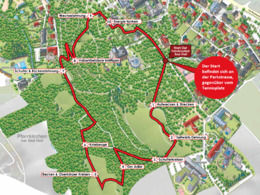
Yolatespath© Bad Hall
Starting place: 4540 Bad Hall
Destination: 4540 Bad Hall

YOLATES© creates awareness and leads to one's own balance.
The Yolatespfad Bad Hall makes the exciting path to your own well-being additionally a nature experience. By walking through nature, the supply of oxygen, you draw additional strength. One actively recovers and the exercises offer the possibility to better understand the signals of one's own body. The exercises help to get to know one's own body better, to promote the dialogue between body and mind and to find the individual harmony.... Starting place: 4540 Bad Hall
Destination: 4540 Bad Hall
duration: 0h 33m
length: 1,8 km
Altitude difference (uphill): 50m
Altitude difference (downhill): 56m
Lowest point: 357m
Highest point: 402m
difficulty: easy
condition: easy
panoramic view: Individual Views
Paths covering:
Hiking trail
further information:
- Flatly
Details - hiking
- themed path
- All weather
- Suitable for seniors
- Suitable for single travelers
- Spring
- Summer
- Autumn
Please get in touch for more information.
4540 Bad Hall
Phone +43 7258 7200
E-Mail info@bts-tourismus.at
Web www.badhall.at
https://www.badhall.at


