

ARNBERGER Runde


- Suitable for families
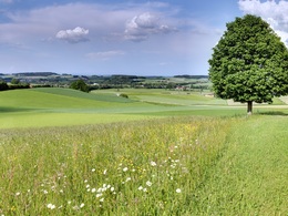
- Flatly
Interactive elevation profile
Create PDF
Tour-Details
Path number: I
Starting place: 4923 Lohnsburg am Kobernaußerwald
Destination: 4923 Lohnsburg am Kobernaußerwald
duration: 2h 12m
length: 7,2 km
Altitude difference (uphill): 217m
Altitude difference (downhill): 217m
Lowest point: 579m
Highest point: 685m
difficulty: easy
condition: easy
panoramic view: Some Views
Paths covering:
Hiking trail
powered by TOURDATA
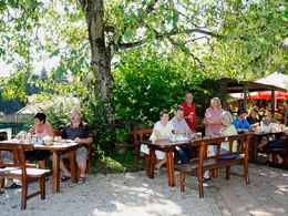
The route leads to Schlag and through the forest to Warmanstadl. Then begins a demanding stretch with a steady incline. Then it goes downhill again to the Grubmühlbach brook from there the path runs steeply uphill again to the "Schlaga Stub'm" inn, where there is the opportunity for a cozy stop and for children there is a petting zoo and outdoor play area.
- Suitable for groups
- Suitable for teenagers
- Suitable for seniors
- Suitable for single travelers
- Suitable for friends
- Suitable for couples
- Suitable for children
- Spring
- Summer
- Autumn
- Early winter
Please get in touch for more information.
4923 Lohnsburg am Kobernaußerwald
Phone +43 7754 4110
E-Mail gemeinde@lohnsburg.at
Web www.lohnsburg.at
http://www.lohnsburg.at
You can also visit us on
Visit us on Facebook")
Interactive elevation profile
Create PDF
Tour-Details
Path number: I
Starting place: 4923 Lohnsburg am Kobernaußerwald
Destination: 4923 Lohnsburg am Kobernaußerwald
duration: 2h 12m
length: 7,2 km
Altitude difference (uphill): 217m
Altitude difference (downhill): 217m
Lowest point: 579m
Highest point: 685m
difficulty: easy
condition: easy
panoramic view: Some Views
Paths covering:
Hiking trail
powered by TOURDATA