

ALM-Runde
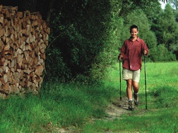


- Suitable for families
- Flatly
Interactive elevation profile
Create PDF
Tour-Details
Starting place: 4923 Lohnsburg am Kobernaußerwald
Destination: 4923 Lohnsburg am Kobernaußerwald
duration: 1h 37m
length: 5,8 km
Altitude difference (uphill): 107m
Altitude difference (downhill): 107m
Lowest point: 480m
Highest point: 574m
difficulty: easy
condition: easy
panoramic view: Individual Views
Paths covering:
Hiking trail
powered by TOURDATA
Via the Goderbauernberg hill it goes to the Schaubach brook. From there uphill in the direction of Rödt. Continue through the forest to the restaurant "zur Alm". The rest of the route leads downhill towards Dopplhub, then crossing the Schaubach brook back to Magetsham.
- Suitable for groups
- Suitable for teenagers
- Suitable for seniors
- Suitable for single travelers
- Suitable for friends
- Suitable for couples
- Suitable for children
- Spring
- Summer
- Autumn
- Early winter
- Deep winter
Please get in touch for more information.
4923 Lohnsburg am Kobernaußerwald
Phone +43 7754 4110
E-Mail gemeinde@lohnsburg.at
Web www.lohnsburg.at
http://www.lohnsburg.at
You can also visit us on
Visit us on Facebook")
Interactive elevation profile
Create PDF
Tour-Details
Starting place: 4923 Lohnsburg am Kobernaußerwald
Destination: 4923 Lohnsburg am Kobernaußerwald
duration: 1h 37m
length: 5,8 km
Altitude difference (uphill): 107m
Altitude difference (downhill): 107m
Lowest point: 480m
Highest point: 574m
difficulty: easy
condition: easy
panoramic view: Individual Views
Paths covering:
Hiking trail
powered by TOURDATA