

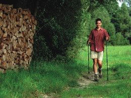
HARTJES-Weg


- culturally interesting
- Flatly
Interactive elevation profile
Create PDF
Tour-Details
Path number: Nr. 1
Starting place: 4925 Pramet
Destination: 4925 Pramet
duration: 5h 9m
length: 18,0 km
Altitude difference (uphill): 380m
Altitude difference (downhill): 384m
Lowest point: 504m
Highest point: 717m
difficulty: medium
condition: medium
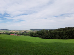
panoramic view: Great panorama
Paths covering:
Hiking trail
powered by TOURDATA
information: Akutmeldung/Information
The "Hartjes-trail" starts directly in the village center at the municipal office of Pramet.
You start in the direction of the neighboring community of Schildorn and hike a short distance on the "Müaderl path" to the "Wirt in der Au" inn. From there you continue along the border to Schildorn until you reach the high Hausruck forest. From there you have a wonderful view of the communities of Pramet and Schildorn. Continue along the long-distance hiking trails "Hausruck-Kobernaußer forest" and "Marienweg" path as well as the legendary trail "1er Weg". Stay on this until you see the sign "to bathing lake" for the first time, then turn left and continue on the "Wurzlweg" trail, which is only open to hikers.
After mastering this somewhat more difficult section, you reach the idyllically situated Prameter bathing lake. From there the trail goes uphill towards the "Gehholz- road" and to the municipal border of Pramet and Eberschwang. When you leave the Hausruck forest from this road, you can enjoy a wonderful panorama in good weather. Afterwards you leave the asphalted road and go along a meadow path in the direction of Gutensham. Once there, you return to the village center on a sidewalk along the main road, where you can enjoy a snack at the "Kirchenwirt" inn or the "Prameter-Hof" inn before heading home.
- Suitable for groups
- Suitable for teenagers
- Suitable for single travelers
- Suitable for friends
- Suitable for couples
- Spring
- Summer
- Autumn
- Early winter
Please get in touch for more information.
4925 Pramet
Phone +43 7754 8450
E-Mail gemeinde@pramet.ooe.gv.at
Web www.pramet.at
http://www.pramet.at
You can also visit us on
Visit us on Facebook")
")
")

Interactive elevation profile
Create PDF
Tour-Details
Path number: Nr. 1
Starting place: 4925 Pramet
Destination: 4925 Pramet
duration: 5h 9m
length: 18,0 km
Altitude difference (uphill): 380m
Altitude difference (downhill): 384m
Lowest point: 504m
Highest point: 717m
difficulty: medium
condition: medium
panoramic view: Great panorama
Paths covering:
Hiking trail
powered by TOURDATA