Klettersteig Hochkogel im Toten Gebirge
Starting place: 4802 Ebensee
Destination: 4802 Ebensee

Via ferrata Hochkogel -
Crossing of the small and large Rauen Kogel
Difficulty level C/D
This via ferrata is not a beginners' via ferrata, but a challenging tour with an alpine character and corresponding alpine dangers, such as falling rocks and weather conditions.
Rescue measures are only possible to a limited extent.
Therefore absolutely necessary:
- Climbing harness
- Via ferrata set
- Rockfall helmet
Difficulty: C/D
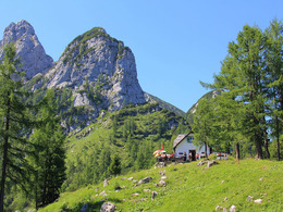
Approach: approx. 15 min from the hut
Descent: approx. 30 min to the hut
Climbing metres: approx. 600 m
Metres in altitude Kl. Rauherkogel: 120 m
Metres in altitude Gr. Rauherkogel : 100 m
To get to the entrance near the Hochkogelhütte, take hiking trail 211 from the Schwarzenbach car park. If you don't want to complete the ascent, via ferrata, return hike and descent in one day, you can spend the night in the Hochkogelhütte.
Note: Reservations for sleeping places are only accepted by telephone.
Starting place: 4802 Ebensee
Destination: 4802 Ebensee
duration: 4h 36m
length: 5,5 km
Altitude difference (uphill): 1.176m
Altitude difference (downhill): 28m
Lowest point: 519m
Highest point: 1.667m
difficulty: medium
condition: difficult
panoramic view: Great panorama
Paths covering:
Climbing mount, Gravel, Hiking trail, Other
further information:
- Possible accommodation
- Board possible
Details - climbing mount
Parking
- Parking space: 60
Most economical season
- Spring
- Summer
- Autumn
Please get in touch for more information.
4802 Ebensee
Phone +43 676 83940493
E-Mail ebensee@naturfreunde.at
Web www.hochkogelhaus-ebensee.at/touren
Web www.ebensee.naturfreunde.at/service…
http://www.hochkogelhaus-ebensee.at/touren
http://www.ebensee.naturfreunde.at/service/huetten-haeuser/hochkogelhaus
http://www.ebensee.naturfreunde.at/service/huetten-haeuser/hochkogelhaus


