© Photo: Oberösterreich Tourismus GmbH./Robert Maybach: Enjoy the view in Upper Austria
Enjoy the view in Upper Austria
search
Search
Close

Bad Hall Rennrad Tour Kultour

 Interactive elevation profile

Download GPS data
Create PDF

Tour-Details

Starting place: 4540 Bad Hall
Destination: 4540 Bad Hall

duration: 4h 27m
length: 117,0 km
Altitude difference (uphill): 1.616m
Altitude difference (downhill): 1.622m

difficulty: difficult
condition: difficult
panoramic view: Great panorama

Paths covering:
Asphalt

powered by TOURDATA

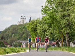
Ride to the 3 abbeys, Schlierbach, Kremsmünster and St Florian with a climb (Oberschlierbach) at the beginning and before St Florian.

The tour, which is peppered with cultural highlights, begins tranquilly: via Adlwang, known for its "Augenbründl" and the "Golden Saturday Nights" (Kirtag in October), to Nußbach. There, the ascent to Oberschlierbach via the "Thürschelm" farm track gets sporty, then logically fast - the descent to Kirchdorf has high-speed potential. The first of the three abbeys, Schlierbach, nestles against the gentle slopes of the Krems Valley, which you cycle up to Hofern. Then it's across the wide valley floor through rural settlements to Wartberg, from where you crank briefly up to Ried im Traunkreis. After abbey number two, Kremsmünster, the average speed increases significantly - the route continues downstream along the Krems to Ansfelden, where you take a "Scheibenschupferl" to the third and final abbey. After St. Florian, the journey home from the centre of Upper Austria takes you along district roads with little traffic. Save your energy for the gentle but steady climb southwards ...


Travelling by public transport
Route planner for independent travellers
  • Suitable for single travelers
  • Suitable for friends
  • Suitable for couples
Most economical season
  • Spring
  • Summer
  • Autumn

Please get in touch for more information.


Bad Hall Rennrad Tour Kultour
Tourismusverband Bad Hall
Kurpromenade 1
4540 Bad Hall

Phone +43 7258 7200 - 0
E-Mail info@badhall.at
Web www.badhall.at
https://www.badhall.at

We speak the following languages

German

 Interactive elevation profile

Download GPS data
Create PDF

Tour-Details

Starting place: 4540 Bad Hall
Destination: 4540 Bad Hall

duration: 4h 27m
length: 117,0 km
Altitude difference (uphill): 1.616m
Altitude difference (downhill): 1.622m

difficulty: difficult
condition: difficult
panoramic view: Great panorama

Paths covering:
Asphalt

powered by TOURDATA