

Hike to Bienenhof Attersee with Bee Trail


- pets allowed
- All weather
- Suitable for families
- Suitable for pushchairs
Interactive elevation profile
Create PDF
Tour-Details
Starting place: 4864 Attersee am Attersee
Destination: 4864 Attersee am Attersee
duration: 0h 22m
length: 1,2 km
Altitude difference (uphill): 63m
Lowest point: 483m
Highest point: 546m
difficulty: easy
condition: easy
panoramic view: Some Views
Paths covering:
Gravel, Hiking trail
powered by TOURDATA
The bee educational trail is freely accessible at all times, weekly tours for children, adults and groups in summer.
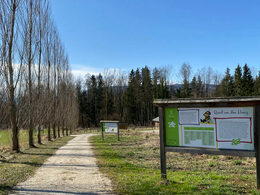
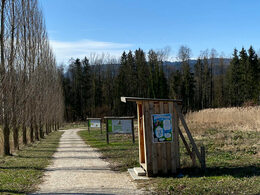
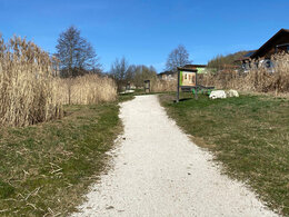
The hike takes you along the Atterseebahn on a hiking trail past flowering meadows and fields. On the right, the local mountain of Attersee - the Buchberg - is shown in all its glory, while the nature reserve of the “Reinthaller Moos” gradually opens up on the left.
After just 15 minutes on foot, you have reached the bee educational trail, which now invites you to immerse yourself in the world of bees and their products. Around 30 display boards invite you to experience & learn with all your senses. The nature trail also includes various beehives and nice places to stay. In the beekeeping, which is located directly at the farm shop, the purest organic honey is bottled. In the farm shop itself, honey from all over the world and other beekeeping products are waiting for its visitors. The small gastronomy also allows a relaxing break.
Starting point: Train Station in Attersee am Attersee
Destination: Beefarm "Bienenhof Attersee", Neuhofen
further information:
- Experience of nature
- Board possible
Details - hiking
- educational path
")
")
")
Accessibility / arrival
Car:
From Salzburg via A1 - exit St. Georgen im Attergau - left direction Attersee.
From Vienna/Linz via A1 - exit St. Georgen im Attergau - left direction Attersee
From the west - Bad Ischl - Weißenbachtal - Unterach - Nußdorf - Attersee - direction St. Georgen
By train:
Coming from Salzburg or Linz/Vienna to Vöcklamarkt, continue with the Atterseebahn to Attersee.
Plane:
From Salzburg via A1 - exit St. Georgen im Attergau - left direction Attersee.
From Vienna/Linz via A1 - exit St. Georgen im Attergau - left direction Attersee
- Parking space: 10
- Bus parking space: 1
Depending on the season, paid parking.
- All weather
- Suitable for groups
- Suitable for schools
- Suitable for kids (3 - 14 Year)
- Suitable for pushchairs
- Pets allowed
- Suitable for teenagers
- Suitable for seniors
- Suitable for single travelers
- Suitable for friends
- Suitable for couples
- Suitable for children
- Spring
- Summer
- Autumn
- Early winter
Please get in touch for more information.
")
Neuhofen 5
4864 Attersee am Attersee
Phone +43 7666 20845
E-Mail hof@bienenhofattersee.at
Web www.bienenhofattersee.at
Web attersee-attergau.salzkammergut.at
http://www.bienenhofattersee.at
https://attersee-attergau.salzkammergut.at
https://attersee-attergau.salzkammergut.at
You can also visit us on
Visit us on Facebook Visit us on Instagram Visit us on Pinterest Visit our videochannel on YouTube WikipediaInteractive elevation profile
Create PDF
Tour-Details
Starting place: 4864 Attersee am Attersee
Destination: 4864 Attersee am Attersee
duration: 0h 22m
length: 1,2 km
Altitude difference (uphill): 63m
Lowest point: 483m
Highest point: 546m
difficulty: easy
condition: easy
panoramic view: Some Views
Paths covering:
Gravel, Hiking trail
powered by TOURDATA