© Photo: Oberösterreich Tourismus GmbH./Robert Maybach: Enjoy the view in Upper Austria
Enjoy the view in Upper Austria
search
Search
Close

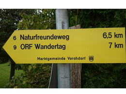
Naturfreunderunde

  • Suitable for families
  • Flatly

 Interactive elevation profile

Download GPS data
Create PDF

Tour-Details

Path number: 6
Starting place: 4655 Vorchdorf
Destination: 4655 Vorchdorf

duration: 1h 56m
length: 6,5 km
Altitude difference (uphill): 168m
Altitude difference (downhill): 169m

Lowest point: 453m
Highest point: 621m
difficulty: easy
condition: easy
panoramic view: No view

Paths covering:
Asphalt, Gravel

powered by TOURDATA

Beautiful hiking trail!

Pamet primary school - Güterweg Kreilesberg - Ditl Moos - Hirschleiten - Groß Helmberg - (Attention in the deer enclosure - please take special care! Do not feed! Dogs on a lead!
Sturdy shoes - as the path through the enclosure is often very muddy) - Ameishaufen - turn off Güterweg Kiemeswang back to school
Travelling by public transport
Route planner for independent travellers
  • Suitable for groups
  • Suitable for single travelers
  • Suitable for families
  • Suitable for friends
  • Suitable for couples
  • Suitable for children
Most economical season
  • Spring
  • Summer
  • Autumn
  • Early winter

Please get in touch for more information.


Naturfreunderunde
Tourismusverband Almtal
Im Dorf 17
4655 Vorchdorf

Phone +43 7616 8268
Fax machine +43 7616 8895
E-Mail info@almtal.at
Web www.almtal.at
http://www.almtal.at

We speak the following languages

German

 Interactive elevation profile

Download GPS data
Create PDF

Tour-Details

Path number: 6
Starting place: 4655 Vorchdorf
Destination: 4655 Vorchdorf

duration: 1h 56m
length: 6,5 km
Altitude difference (uphill): 168m
Altitude difference (downhill): 169m

Lowest point: 453m
Highest point: 621m
difficulty: easy
condition: easy
panoramic view: No view

Paths covering:
Asphalt, Gravel

powered by TOURDATA