

From Gahberg on the Hefelberg to Schörfling


- pets allowed
- All weather
- Suitable for families
Interactive elevation profile
Create PDF
Tour-Details
Starting place: 4852 Weyregg am Attersee
Destination: 4861 Schörfling am Attersee
duration: 1h 58m
length: 5,3 km
Altitude difference (uphill): 387m
Altitude difference (downhill): 38m
Lowest point: 483m
Highest point: 834m
difficulty: medium
condition: medium
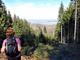
panoramic view: Some Views
Paths covering:
Asphalt, Gravel, Hiking trail, Other
powered by TOURDATA
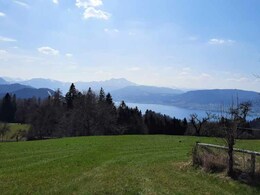
A recommendable hike is the hike from the Gahberg in Weyregg over the Häferlberg to Schörfling! If enough time is planned, you can hike back to the starting point. An alternative would be the return trip by boat in the summer months.
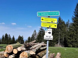
The entry point to this hike is near the panorama board on the Gahberg.
Variant A:
On the Gahbergstraße (near the panorama panel) you will find the entry point to the Häferlberg (family route). At the cross you walk over the Binderschuß to Schörfling and Kammer - the walking time is about 1 1/2 hours.
Variant B:
At the Gahberg junction (next to the transmitter mast) turn left to the two farms following the signs Steig/Häferlberg and after 20 minutes you will reach the forest road. Pass the houses to the cross and continue to Schörfling - the walking time is about 2 hours.
There are two possibilities to return to Weyregg:
In July and August with the Attersee Schifffahrt on the north circular route or with bus No. 562.
Refreshment stops in the region:
Places of interest at the Gahberg station:
Starting point: Gahbergstraße in Weyregg am Attersee
Destination: In Schörfling - parking place "Seebad Schönauer"
Accessibility / arrival
Car:
From Salzburg via the A1 - Seewalchen exit continue in the direction of Weyregg.
From Vienna/Linz via A1 - Exit Schörfling or Seewalchen further direction Weyregg
From the west - Bad Ischl-Weißenbach-Steinbach-Weyregg
By train:
Coming from Salzburg or Linz/Vienna to Attnang-Puchheim or Vöcklabruck - continue with Kammer Bahn to BH Kammer Schörfling and from there with bus line 562 to Weyregg.
Plane:
From Salzburg via the A1 - Seewalchen exit continue in the direction of Weyregg.
From Vienna/Linz via the A1 - exit Schörfling or Seewalchen continue in the direction of Weyregg
Parking possibility in Weyregg:
- Parking next to the fire station in Weyregg
- Parking space: 10
- All weather
- Suitable for groups
- Suitable for schools
- Suitable for kids (5 - 14 Year)
- Pets allowed
- Suitable for teenagers
- Suitable for seniors
- Suitable for single travelers
- Suitable for friends
- Suitable for couples
- Suitable for children
- Spring
- Summer
- Autumn
- Early winter
Please get in touch for more information.
4852 Weyregg am Attersee
Phone +43 7666 7719 - 70
E-Mail info.weyregg@attersee.at
Web attersee-attergau.salzkammergut.at
https://attersee-attergau.salzkammergut.at
")
")
")
")
Interactive elevation profile
Create PDF
Tour-Details
Starting place: 4852 Weyregg am Attersee
Destination: 4861 Schörfling am Attersee
duration: 1h 58m
length: 5,3 km
Altitude difference (uphill): 387m
Altitude difference (downhill): 38m
Lowest point: 483m
Highest point: 834m
difficulty: medium
condition: medium
panoramic view: Some Views
Paths covering:
Asphalt, Gravel, Hiking trail, Other
powered by TOURDATA