Schlögener Donaublick
Path number: 54, 56
Starting place: 4083 Haibach ob der Donau
Destination: 4083 Haibach ob der Donau


Flatly
Possible accommodation
Kirchenplatz 4
4083 Haibach ob der Donau
4083 Haibach ob der Donau

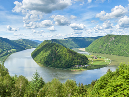
The Danube Loop Schlögen - the natural wonder of Upper Austria
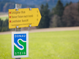
We start our hike in the centre of Haibach. Car parks at the municipality, building yard and indoor swimming pool. We follow the yellow signs "Schlögener Blick". The path leads us via the villages of Dorf, Oedt and Schlögenleiten to the well-known vantage point.Alternative: Descent to Inzell - 3/4 hrs.
- Suitable for groups
- Suitable for schools
- Suitable for families
- Spring
- Summer
- Autumn
- Early winter
- Deep winter
Please get in touch for more information.
Kirchenplatz 4
4083 Haibach ob der Donau
E-Mail haibach@oberoesterreich.at
Web www.donauregion.at/haibach
https://www.donauregion.at/haibach