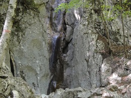
Jainzen Round Walk (Hohenzoller Waterfall)
Path number: 3
Starting place: 4820 Bad Ischl
Destination: 4820 Bad Ischl
Distance: 7 km (6 km without Hohenzollern waterfall)
Walking time: 2 hours 15 minutes (1 hour 45 minutes without Hohenzollern waterfall)
Difference in altitude: ascent and descent 240 m (160 m without Hohenzollern waterfall)
Trail conditions: partly asphalt, some gravel, forest road, few steps
Here you can shorten the trail by about 30 minutes, if you follow the asphalted road.
However, for the main trail follow the farm track through the farm and descend to the houses in Jainzen. From here it is only 5 minutes walk to the "Lucky Place" at the Hohenzollern waterfall. In summer this is a canyoning route and in winter it is used for ice climbing. Follow the route back to the houses and take Jainzentalstraße until reaching a small church, turn right onto a farm track. The track goes through a peaceful valley with meadows and woods, and eventually along the original Jainzen brook slightly downhill. The path passes a monument, to Crown Prince Rudolf marking the point where he shot his first deer in 1867.The path reaches the houses in the village of Roith. Follow the signed road and farm tracks to Bad Ischl. The route meets the main road, from here it is only a few minutes walk to the centre.
Path number: 3
Starting place: 4820 Bad Ischl
Destination: 4820 Bad Ischl
duration: 2h 16m
length: 7,0 km
Altitude difference (uphill): 262m
Altitude difference (downhill): 261m
Lowest point: 465m
Highest point: 601m
difficulty: easy
condition: easy
panoramic view: Individual Views
Paths covering:
Asphalt, Gravel, Hiking trail
Details - hiking
- themed path
- Suitable for groups
- Suitable for schools
- Pets allowed
- Suitable for families
- Spring
- Summer
- Autumn
Please get in touch for more information.
4820 Bad Ischl
Phone +43 6132 27757
E-Mail office@badischl.at
Web www.badischl.at
http://www.badischl.at


