Winter trail Obertraun
4831 Obertraun

Wild-romantic hiking trail on the banks of the Traun
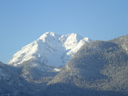
Ice crystals reflected in the sun, the beautiful winter landscape surrounded by the imposing mountain scenery and the soft crunching of the snow under our shoes ...
Fabulous winter hiking country
On this short hike throug the fairy-tale snowy landscape you can enjoy the magic of the cold season. The beautiful hiking trail along the banks of the river Traun leads us into the woodlands, deep in snow. Our destination is the “Ebnersteg”. We cross the bridge and walk along the opposite bank of the river, back to our start point.
On this short hike you can enjoy the beauty of a winter landscape surrounded by the imposing mountain scenery.
An alternative is to walk through the village of Obertraun to the start point.
Mountain rescue: 140
Order Hiking- and Mountain Biking Maps...
Experience a 360° panorama tour through Obertraun…
Paths covering:
further information:
- Flatly
Details - hiking
- cleared winter hiking path
Depending on the weather, daily walkable. The path is cleared in winter.
by car
from Salzburg:
Federal road B158 direction Bad Ischl
in Bad Ischl driveway onto Salzkammergut Straße B145 in direction to Bad Goisern, Hallstatt and Obertraun, before the bridge turn right to the former inn Dachsteinhof
from Linz:
A1 motorway exit Regau on Salzkammergut Straße B145 direction Gmunden, Bad Goisern, Hallstatt and Obertraun, before the bridge turn right to the former inn Dachsteinhof
from Graz:
A9 motorway exit Liezen on B320
in Trautenfels turn onto Salzkammergut Straße B145 via Bad Aussee to Obertraun, after the bridge turn left to the former inn Dachsteinhof
from Villach:
A10 Tauernautobahn to exit "Eben im Pongau", from there via Annaberg, Gosau and Hallstatt to Obertraun, before the bridge turn right from there 1 km walk to the begining of the hiking trail.
by bus:
get off at the bus station “Obertraun Bundessportzentrum”, from there 500 walk to the begining of the hiking trail.
by train:
from Linz/Salzburg to Attnang-Puchheim, change to train to Stainach-Irdning
or from Stainach-Irdning Zug direction Attnang-Puchheim
get off at train station "Obertraun-Dachsteinhöhlen", from there 2 km walk to the begining of the hiking trail.
Parkarea is at the starting point - from there you start the roadway.
- Parking space: 10
- Bus parking space: 1
free parking
- All weather
- Suitable for groups
- Suitable for schools
- Suitable for kids (3 - 14 Year)
- Pets allowed
- Suitable for teenagers
- Suitable for seniors
- Suitable for single travelers
- Suitable for families
- Suitable for friends
- Suitable for couples
- Suitable for children
- Early winter
- Deep winter
Please get in touch for more information.
Obertraun 180
4831 Obertraun
Phone +43 5 95095 - 40
E-Mail obertraun@dachstein-salzkammergut.at
Web www.dachstein-salzkammergut.at
You can also visit us on
Facebook Instagram Pinterest YouTube Wikipedia


