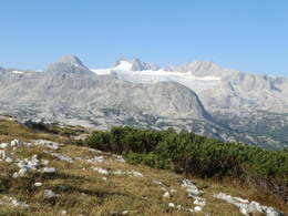
Seewand fixed rope route

This via ferrata was established by mountain guides Helmut Putz and Gerhard Gangl, in cooperation with the Obertraun Tourist Authorities, in autumn 1997. It is permanently being maintained, and has a difficulty rating of D to E (on a scale from A to E), and as such is one of the most challenging rock climbs in the entire Alpine world.
A challenging fixed rope route
It takes 4 to 6 hours to complete the climb, and those seeking to undertake the challenge must be in excellent condition, and carry all the necessary safety and climbing equipment. The via ferrata is available from the end of June to the middle of October.
With an altitude difference of almost 800 metres and its exhilerating views towards Hallstatt, Lake Hallstatt and the entire Holiday Region Dachstein Salzkammergut, this climb is certainly the greatest of its kind in Austria.
The terrain you encounter throughout this very challenging adventure is almost entirely solid rock, apart from one green section in the middle. At the far end of this green section there is a small cave which is practical for sheltering from the weather and for bivouacs. If you otherwise wish to take a short break, there are some wonderful places along the rock wall with stunning views to admire. When you have at last conquered this very challenging third of the route, itis time to reward yourself with a snack and time to enjoy the breath-taking panoramic views.
The final section is a gentle, marked trail, which takes about 40 minutes, and covers part of the Dachstein plateau. This leads you to the Gjaid Alm, a catered mountain hut which is famous for its "Kaiserschmarrn", a local sweet specialty. You can then take the Dachstein Krippenstein cable car back down to the valley or hike down, which takes about 3 to 4 hours.
Plan before you go to have a safe climb
- Enquire about snow fall/how much snow there is in the area you will be visiting
- Consider taking snow shoes to make your arrival on the Gjaidlam easier!
- Avoid climbing if stormy weather is on its way. Lightning storms can endanger your life!
- Always carry proper equipment and bring a light rope with you for your safety.
- Pack sufficient refreshments and snacks
- Ensure you are carrying plenty of drinks
- Be aware of the latest return to the valley by cable car (17.00 in peak season; 16.30 at all other times!) It takes 3.5 to 4 hours to walk back down to Obertraun.
In case of emergency call the mountain rescue under 140
Download the via ferrata guide of Bad Goisern, Gosau at Dachstein, Hallstatt and Obertraun.
To the 360° panorama tour tour through the Holiday Region Dachstein Salzkammergut
Paths covering:
further information:
- Possible accommodation
- Board possible
Details - climbing mount
- difficulty acc. to Kurt Schall: extremely difficult (E)
- Hop off description: Start out from the large car park by the "Kesselgruende" public bathing area half way between Hallstatt and Obertraun. Here there is an information board which displays essential information and some practical tips. A footpath leads to the Hirschaualm (approx. 40 mins) where the ascent begins.
- Hop on description: The final section is a gentle, marked trail, which takes about 40 minutes, and covers part of the Dachstein plateau. This leads you to the Gjaidalm, a catered mountain hut which is famous for its "Kaiserschmarrn", a local sweet specialty. You can then take the Dachstein Krippenstein cable car back down to the valley or hike down which takes about 3 to 4 hours.
- duration hop on: 1 h
- duration climbing mount: 6 h
- duration Descent: 2 h
Please pay attention to the weather conditions and the snow at the open times of the Dachstein Krippenstein cablecar.
by car
from Salzburg:
Federal road B158 direction Bad Ischl
in Bad Ischl driveway onto Salzkammergut Straße B145 in direction to Bad Goisern, Hallstatt
from Linz:
A1 motorway exit Regau on Salzkammergut Straße B145 direction Gmunden, Bad Goisern, Hallstatt
from Graz:
A9 motorway exit Liezen on B320
in Trautenfels turn onto Salzkammergut Straße B145 via Bad Aussee to Hallstatt
from Villach:
A10 Tauernautobahn to exit "Eben im Pongau", from there via Annaberg, Gosau to Hallstatt
From Hallstatt you follow the street to Obertraun until you reach the "Kesselkurve" after the first tunnel. There is a parking area at the lakeside (P5), the signs to the via ferrata are on the mountainside of the street.
by train
arriving at "train station Hallstatt", take the ferry to Hallstatt, from the pier you walk 20 minutes
by bus
you arrive at the busterminal „Hallstatt Lahn“, from there it is a five minute walk
Detailed information on the respective train and bus times can be found at https://www.oebb.at/en/ (train) and https://www.postbus.at/en(bus).
- Parking space: 20
- Suitable for couples
- Summer
Please get in touch for more information.
4830 Hallstatt
Phone +43 6135 6058
E-Mail office@outdoor-leadership.com
Web www.dachstein-salzkammergut.at
Web www.outdoor-leadership.com
http://www.outdoor-leadership.com
You can also visit us on
Facebook Instagram Pinterest YouTube Wikipedia


