

Pirauloipe


- Suitable for families
- culinary interesting
- Flatly
- Possible accommodation
Interactive elevation profile
Create PDF
Tour-Details
Starting place: 4261 Rainbach im Mühlkreis
Destination: 4261 Rainbach im Mühlkreis
duration: 3h 36m
length: 13,6 km
Altitude difference (uphill): 167m
Altitude difference (downhill): 167m
Lowest point: 656m
Highest point: 736m
difficulty: medium
condition: medium
panoramic view: Some Views
Paths covering:
snow
powered by TOURDATA
information: Akutmeldung/Information
Trail not in operation
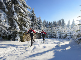
Cross-country skiing in the winter landscape of the Freistadt region.Rainbach im Mühlkreis is located in the Freistadt region and offers all cross-country skiing fans a wide range of trails.
The extensive network of trails leads past small, romantic streams across unspoilt meadow slopes in the midst of a snow-covered, peaceful winter landscape. Both beginners and cross-country skiing professionals can enjoy cross-country skiing on trails of various lengths, in classic or skating style.
In future, it will be possible to access this trail at the railway subway in Summerau.
There will again be a ticket office at the start of the trail. We ask for voluntary donations for the cross-country ski track equipment and ongoing operation.
Information on the current trail situation can be found here: +43 (0)7949/6255
- Suitable for groups
- Suitable for schools
- Suitable for teenagers
- Suitable for seniors
- Suitable for single travelers
- Suitable for friends
- Suitable for couples
- Deep winter
Please get in touch for more information.
Prager Straße 5
4261 Rainbach im Mühlkreis
Phone +43 7949 6255
E-Mail gemeinde@rainbach-muehlkreis.ooe.gv.at
Web www.muehlviertel-almfreistadt.at/th…
https://www.muehlviertel-almfreistadt.at/themen/winter/langlaufen.html
Interactive elevation profile
Create PDF
Tour-Details
Starting place: 4261 Rainbach im Mühlkreis
Destination: 4261 Rainbach im Mühlkreis
duration: 3h 36m
length: 13,6 km
Altitude difference (uphill): 167m
Altitude difference (downhill): 167m
Lowest point: 656m
Highest point: 736m
difficulty: medium
condition: medium
panoramic view: Some Views
Paths covering:
snow
powered by TOURDATA