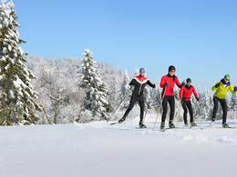
Skatingloipe, St. Stefan-Afiesl
Starting place: 4170 St. Stefan-Afiesl
Destination: 4170 St. Stefan-Afiesl
St. Stefan am Walde 65
4170 St. Stefan-Afiesl
4170 St. Stefan-Afiesl

Not in operation
Medium difficulty running route. Good basic condition required. Mostly paved paths. No special skill required.
Starting place: 4170 St. Stefan-Afiesl
Destination: 4170 St. Stefan-Afiesl
duration: 1h 30m
length: 13,4 km
Altitude difference (uphill): 220m
Altitude difference (downhill): 220m
Lowest point: 810m
Highest point: 920m
difficulty: medium
condition: medium
panoramic view: Great panorama
Paths covering:
snow
Starting point: Hotel AVIVA, Hotel Bergergut, Helfenberger Hütte
Destination: the respective starting point. The round is marked with A2.
Details - Trail
- Nordic skiing facilities: Marked Nordic skiing run
- Type of Nordic skiing run: Skating
Open every day when the snow is Right.
- Suitable for groups
- Suitable for schools
- Suitable for kids (10 - 14 Year)
- Suitable for teenagers
- Suitable for seniors
- Suitable for single travelers
- Suitable for families
- Suitable for friends
- Suitable for couples
- Suitable for children
- Deep winter
Please get in touch for more information.
St. Stefan am Walde 65
4170 St. Stefan-Afiesl
Phone +43 7216 7010
E-Mail gemeinde@ststefan-afiesl.at
Web www.ststefan-afiesl.at
Web www.muehlviertel.at/
http://www.ststefan-afiesl.at
https://www.muehlviertel.at/
https://www.muehlviertel.at/


