Leidinger - Irrsberg - Gaisberg
Starting place: 5310 Mondsee am Mondsee
Destination: 5310 Mondsee am Mondsee
Dr. Franz Müller Straße 3
5310 Mondsee am Mondsee
5310 Mondsee am Mondsee

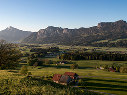
Maybe the most beautiful view over MondSeeLand!
We go through Rainerstraße and Ludwig-Angerer-Straße to Zellerache. We follow Hierzenbergerstraße upstream. At the parking lot after the underpass, hiking trail no.35 branches off to the left. On this we cross the Ache and climb the forest path to the Gaisberg. At Lindenweg we come to Gaisbergstraße and follow it up to Pension Leidinger. (At the intersection after the motorway underpass, walk uphill to the left! Path No. 8) A bench by the roadside invites you to enjoy the view. We continue hiking, past the Hotel Gasthof Leidingerhof **** and the Gastehaus Stabauer. On the meadow path it goes up to the widely visible wayside shrine. A rest is appropriate here. Now we do not follow the path markings to Kolomansberg, but walk in a south-westerly direction to the right behind the house, come to the driveway and go down. We leave the entrance to the Seppenbauer on the right, we also turn left at the next crossroads and reach the road to the Gasthaus Ölgraben (path no. 35) at the Winkler carpentry shop, which we do not follow. We go straight ahead, cross the autobahn and shortly afterwards reach Thalgaustraße. Here we stay on the left on the bike and sidewalk. After 600 m, the Gaisbergstrasse branches off to the left, on which, after a small ascent from the Gaisberg, we take another look at the MondSeeLand, before we come downhill to the main road (via the small staircase), cross it and come back to the Rainerstrasse, which brings us back to the center. From this path we have one of the most beautiful views of Mondsee, the lake and the surrounding mountains at the highest point, at the wayside shrine "Maria, Königin des Friedens" on the Irrsberg.
This tour including a description was made available to us by the Alpenverein Österreich, Mondsee Section, Mrs. Annelu-Ilse Wenter.
This tour including a description was made available to us by the Alpenverein Österreich, Mondsee Section, Mrs. Annelu-Ilse Wenter.
Starting place: 5310 Mondsee am Mondsee
Destination: 5310 Mondsee am Mondsee
duration: 2h 21m
length: 8,0 km
Altitude difference (uphill): 194m
Altitude difference (downhill): 198m
Lowest point: 488m
Highest point: 668m
difficulty: easy
condition: easy
panoramic view: Great panorama
Paths covering:
Asphalt, Hiking trail
Starting point: Tourist-information in the center of Mondsee.
Destination: Tourist-information in the center of Mondsee.
further information:
- Flatly
- Board possible
Details - hiking
- cleared winter hiking path
Accessibility / arrival
Starting point of this tour is the center of Mondsee. Parking at the lake promenade of Mondsee.
- Parking space: 100
none
- All weather
- Suitable for groups
- Suitable for seniors
- Suitable for single travelers
- Suitable for families
- Suitable for friends
- Suitable for couples
- Suitable for children
- Spring
- Summer
- Autumn
- Early winter
- Deep winter
Please get in touch for more information.
Dr. Franz Müller Straße 3
5310 Mondsee am Mondsee
Phone +43 6232 2270
E-Mail info@mondsee.at
Web mondsee.salzkammergut.at
https://mondsee.salzkammergut.at


