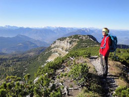
Hohe Schrott
Starting place: 4820 Bad Ischl
Destination: 4820 Bad Ischl
Round trip with a climb over the Mitteralm and descent over the Kotalm
Walking time: 4 hours ascent - descent 3 hoursDifference in altitude: 1400 m ascent, descent 1430m
Requirements: long and strenuous alpine trek
Initially follow the asphalted road, which soon becomes a forest track, turn left uphill after about 25 minutes go right at an intersection with signposts (47 ° 42'21 "N - 013 ° 39'21 " E - 689 m). After a few minutes leave the forest track (Do not go on the road it does not lead to the Hohe Schrott!). At the next sign go left (47 ° 42'20 "N - 013 ° 39'45 " E - 770 m). Follow this to Halbweghütte
( 47 ° 42'37 "N - 013 ° 40'26 " E - 1117 m) then cross a forest track. About 25 minutes above the
Hut, after crossing another forest track, you arrive at an area which has been severly affected by storms in recent years. Pay close attention to the markings. When you reach a forest track, stay on the marked path to the left (47 ° 42'50 "N - 013 ° 41'06 " E - 1309 m). Follow this farm track to its end a few metres below the Mitteralm. Pass by some houses to reach a Signpost (47 ° 43'08 "N - 013 ° 42'04 " E ) in front of a hut. At this point you can go right to Hinteralm. The main trial goes straight ahead. Soon the forest ends and you come to a mountain pine forest zone. This is the
Schrottsattel with a signpost (47 ° 43'36 "N - 013 ° 42'20 " E ). From here it is only 20 minutes to the summit of the Hohe Schrott. (47 ° 43'40 "N - 013 ° 42'41 " E - 1839 m).
On the way down we go back to the Schrotsattel and in a few minutes reach Hochglegt (47 ° 43'33 "N - 013 ° 42'09 " E -1785 m). Now go in a westerly direction down to Kotalm. The route descends into Bad Ischl through an area with more storm damage. The route crosses forest tracks 4 times (watch the markings!) before reaching Rettenbach from where you can walk back to the starting point.
- Suitable for friends
- Suitable for couples
- Summer
Please get in touch for more information.
4820 Bad Ischl
Phone +43 6132 27757
Fax machine +43 6132 27757 - 77
E-Mail office@badischl.at
Web www.badischl.at
http://www.badischl.at


