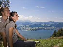
Grünberg West Straße in Gmunden
Starting place: 4810 Gmunden
Destination: 4810 Gmunden
The Grünberg west road runs parallel to the Mitterweg.
Starting point is the Mitterweg. Than follow the forest road till Dürrenberg. Here you can walk either downhill to the shipping piers Ramsau or Hois'n or uphill across Radmoos to the lake Laudachsee. Starting place: 4810 Gmunden
Destination: 4810 Gmunden
duration: 1h 42m
length: 5,0 km
Altitude difference (uphill): 231m
Altitude difference (downhill): 207m
Lowest point: 623m
Highest point: 861m
difficulty: medium
condition: medium
panoramic view: Some Views
Paths covering:
Path / trail, Gravel, Street, Other
Starting point: Mitterweg
Destination: Almweg at Dürrenberg
Accessibility / arrival
from the highway: departure Regau-B 145 in the direction of Bad Ischl-through the center of Gmunden-acorss the bridge "Traunbrücke"-traffic circle first exit-in front of the Gasthof Engelhof turn right till the parking lot "Grübergbauer"/Himmelreichstraße
Most economical season
- Summer
Please get in touch for more information.
Toscanapark 1
4810 Gmunden
Phone +43 7612 74451
E-Mail info@traunsee-almtal.at
Web www.traunsee-almtal.at
http://www.traunsee-almtal.at


