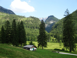
© Photo: Oberösterreich Tourismus GmbH./Robert Maybach: Enjoy the view in Upper Austria
Enjoy the view in Upper Austria
Search
Search
Close

Gamskogel (1628 m)

  • Flatly

 Interactive elevation profile

Download GPS data
Create PDF

Tour-Details

Starting place: 4820 Bad Ischl
Destination: 4820 Bad Ischl

duration: 4h 3m
length: 4,8 km
Altitude difference (uphill): 1.026m
Altitude difference (downhill): 57m

Lowest point: 631m
Highest point: 1.629m
difficulty: medium
condition: medium
panoramic view: Great panorama

Paths covering:
Path / trail

powered by TOURDATA

Grasberg on the edge of the Totes Gebirge
Starting from Rettenbach hut the steep path leads in serpentines past huts and an old hunting lodge. Repeatedly the trail crosses the forestry road, which is longer but another option for getting to Hinteralm pasture. On your ascent you enjoy a fantastic view of Loser Mountain, Hoisenrad Alm pasture and Katrin pasture. One can even admire a wild waterfall which originates at Rotkogl Mountain. After a 2-hour hike one get to the first two huts of Hinteralm pasture. From there one can follow the signposts to five other huts. From Hinteralm pasture a 1-hour hike brings you to Mitteralm pasture or a 1.5-hour hike on top of Gamskogl Mountain. As the name tells (Gams = chamois) Gamskogl is home to many chamois. From the summit cross one enjoys a fantastic panoramic view. Hike the same way back to get to Hinteralm and Rettenbachalm pasture.
Destination: As a starting point

further information:
  • Flatly
  • Board possible

Travelling by public transport
Route planner for independent travellers
Most economical season
  • Spring
  • Summer
  • Autumn

Please get in touch for more information.


Gamskogel (1628 m)
Tourismusverband Bad Ischl
4820 Bad Ischl

Phone +43 6132 27757
Fax machine +43 6132 27757 - 77
E-Mail office@badischl.at
Web www.badischl.at
http://www.badischl.at

We speak the following languages

German

 Interactive elevation profile

Download GPS data
Create PDF

Tour-Details

Starting place: 4820 Bad Ischl
Destination: 4820 Bad Ischl

duration: 4h 3m
length: 4,8 km
Altitude difference (uphill): 1.026m
Altitude difference (downhill): 57m

Lowest point: 631m
Highest point: 1.629m
difficulty: medium
condition: medium
panoramic view: Great panorama

Paths covering:
Path / trail

powered by TOURDATA