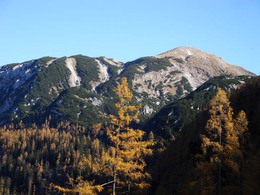
Schönberg (Wildenkogel)
Starting place: 4820 Bad Ischl
Destination: 4820 Bad Ischl
roadblock: Akutmeldung/Sperre
Long Tour of Bad Ischl’s only Mountain over 2000m
Walking time: 5 hours ascent - descent 3 hours 30 minutesDifference in altitude: 1600 meters ascent, descent 1600m
Requirements: Very long mountain tour. If you want to enjoy this tour, it is recommended to
overnight stay in the “Ischler Hütte” (pre-booking is required).
Variations: If the featured descent path is selected from the Hütte, the tour is shortened by 30 minutes.
From the car park in the Rettenbachalm walk on the flat for 20 minutes into the valley to a road junction with a signpost (47 ° 41'21 "N -013 ° 43'41 "E - 665 m). Keep to the right and follow the signs "Ischler Hütte" (Naglsteig). Ignore another turnoff to Ischler Hütte, which is shortly after a road tunnel. After about an hour walk we you reach the beginning of the Naglsteig ( 47 ° 40'47 "N - 013 ° 45'16 " E - 818 m) with a signpost on the right hand side. Leave the forest track and cross the Rettenbach (stream) on a narrow bridge. After about 15 minutes uphill the trail follows a climb with safety ropes, making the further ascent easier (Caution when wet ). At an altitude of 1300 metres you enter a mostly swampy meadow. Keep straight on to Beerensattel (47 ° 41'45 "N - 013 ° 45'21 " E - 1432 m). Descending the trail soon reaches the Schwarzenbergalm with the Ischler Hütte ( 47 ° 42'00 "N - 013 ° 45'39 " E - 1368 m). The remaining climb rises again for a further 2 hours and 30 minutes. Leave the Hütte walking northeast reaching an intersection after 20 minutes ( 47 ° 42'19 "N - 013 ° 46'14 " E - 1485 m). Now the trail gets really tiring. The path leads uphill to the right and soon leaves the forest area. By Latschengassen and over hill and dale, go to the top of the Schönberg opposite. Always pay close attention to the red-white-red markers! Especially on the grassy final climb where it is easy to lose the way! From the summit cross (47 ° 42'45 "N - 013 ° 47'26 " E - 2090 m) on the Ischl side (there is a second summit cross) there is a stunning view over the plateau of the Totes Gebirge and the mountains of the Salzkammergut. Those that are still fit enough can choose the slightly longer route via the NW ridge for the descent. Here you go over the back about 1 hour towards Hochkogelnütte to a saddle (47 ° 43'12 "N - 013 ° 46'48 " E - 1720 m).This way is not supervised by the OeAV section of Bad Ischl. Turn left and continue for a further 40 minutes to an intersection that you already know from the ascent path. From here it is only 15 minutes to the Ischler Hütte. To reach the valley again takes 20 minutes ascending the Beerensattel. Here, however, keep right (sign: "Rettenbachalm" 1 hour 15 minutes). A few minutes later you return to an intersection. At this point there are 2 equally long descents. It is recommended to take the right variant (Route 211). Soon after, there is a view of the Rettenbachalm. At an altitude of about 1000 m, you arrive at a flat path and must soon cross a forest track. On reaching another forest track it is about 25 minutes walk to the car park at the Rettenbachalm.
Starting place: 4820 Bad Ischl
Destination: 4820 Bad Ischl
duration: 10h 49m
length: 20,0 km
Altitude difference (uphill): 1.843m
Altitude difference (downhill): 1.841m
Lowest point: 631m
Highest point: 2.072m
difficulty: medium
condition: medium
panoramic view: Great panorama
Paths covering:
Gravel, Hiking trail
Starting point: Parking Rettenbachalm (47 ° 41'32 "N - 013 ° 42'42 " E - 636 m) Directions:. From Bad Ischl follow the green signs “Rettenbachalm” for about 8 kilometres. No public transport
Destination: As a starting point - round trip
further information:
- Flatly
- Possible accommodation
- Board possible
Most economical season
- Spring
- Summer
- Autumn
Please get in touch for more information.
4820 Bad Ischl
Phone +43 6132 27757
E-Mail office@badischl.at
Web www.badischl.at
http://www.badischl.at


