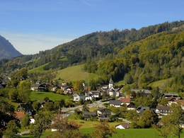
Neukirchen - Windlegern - Neukirchen Circular walk
Starting place: 4814 Altmünster
Destination: 4814 Altmünster
NEUKIRCHEN-WINDLEGERN-NEUKIRCHEN CIRCULAR WALK
Easy hiking tour with impressive panorama.
Option 2A: Windlegern-Altmünster
Gasthaus Windlegern-downhill road -carry on along sealed road after S-shaped bend before farmhouse, turn off to right, slightly downhill,along forest 8game fence), steep sealed road from haus Hollerbühel-Kollmannsbergstraße-Gasthaus Hintenaus-briefly along Buchbergerstraße to the right-turn left to Örach via Hofweg To walk No 7-Eben -Altmünster,
Walking time:21/2 hours,wunderful views,mostly roads.
Option 2B: Eindlegern-Hochsteinalm-langbath valley (Langbath lakes) Gasthaus Windlegern-head south along meadow (chapel)-uphill through forest-turn left into forest road-(option: after 30min. steep descent to Gasthaus "Zur Kreh"-Langbath vallery and Langbath lackes- continue along forest road up to Gasthaus Hochsteinalm -descent towards Traunkirchen /Mühlbachberg along forest road and the signposted path through the wood. Walking time: Windlegern-Kreh 11/2 hours, Windlegern-Hochsteinalm.11/2 hours of forest road Hochsteinalm-Traunkirchen: approx 2 hours
Starting place: 4814 Altmünster
Destination: 4814 Altmünster
duration: 2h 27m
length: 5,8 km
Altitude difference (uphill): 386m
Altitude difference (downhill): 383m
Lowest point: 565m
Highest point: 933m
difficulty: easy
condition: easy
panoramic view: Great panorama
Paths covering:
Hiking trail
Starting point: Neukirchen centre bakery
Destination: Neukirchen
further information:
- Flatly
Accessibility / arrival
from the highway: departure Regau-B 145 in the direction of Bad Ischl-1 km after the place name sign of Altmünster turn right- in the direction of Neukirchen
Most economical season
- Spring
- Summer
- Autumn
Please get in touch for more information.
4814 Altmünster
Phone +43 7612 87181
E-Mail altmuenster@traunsee.at
Web traunsee-almtal.salzkammergut.at/or…
https://traunsee-almtal.salzkammergut.at/orte/altmuenster.html


