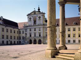
© Photo: Oberösterreich Tourismus GmbH./Robert Maybach: Enjoy the view in Upper Austria
Enjoy the view in Upper Austria
Search
Search
Close

Zu den Mönchen von Kremsmünster

  • Flatly

 Interactive elevation profile

Download GPS data
Create PDF

Tour-Details

Starting place: 4600 Wels
Destination: 4600 Wels

duration: 5h 54m
length: 81,4 km
Altitude difference (uphill): 523m
Altitude difference (downhill): 476m

Lowest point: 310m
Highest point: 539m
difficulty: medium
condition: medium
panoramic view: Individual Views

Paths covering:
Asphalt

powered by TOURDATA

This journey of discovery starts in the old Roman town of Wels. Cyclists are guided via Eberstalzell and Wartberg an der Krems to Kremsmünster with its mighty monastery. The route continues to Rohr. The cyclists return to Wels via Sipbachzell.

Route: Wels (R11 Almtalradweg) - Eberstalzell - Wartberg an der Krems (R13 Traunviertlerradweg) - Kremsmünster (R10 Kremstalradweg) - Rohr - Sipachzell (R12 Voralpenradweg) - Wels
Travelling by public transport
Route planner for independent travellers
Most economical season
  • Spring
  • Summer
  • Autumn

Please get in touch for more information.


Zu den Mönchen von Kremsmünster
Tourismusverband Region Wels
Stadtplatz 44
4600 Wels

Phone +43 7242 67722 - 22
Fax machine +43 732 7277 - 701
E-Mail info@wels.at

We speak the following languages

German

 Interactive elevation profile

Download GPS data
Create PDF

Tour-Details

Starting place: 4600 Wels
Destination: 4600 Wels

duration: 5h 54m
length: 81,4 km
Altitude difference (uphill): 523m
Altitude difference (downhill): 476m

Lowest point: 310m
Highest point: 539m
difficulty: medium
condition: medium
panoramic view: Individual Views

Paths covering:
Asphalt

powered by TOURDATA