© Photo: Oberösterreich Tourismus GmbH./Robert Maybach: Enjoy the view in Upper Austria
Enjoy the view in Upper Austria
Search
Search
Close

Hochkogel in Ebensee

  • Possible accommodation

 Interactive elevation profile

Download GPS data
Create PDF

Tour-Details

Starting place: 4802 Ebensee
Destination: 4802 Ebensee

duration: 3h 15m
length: 5,7 km
Altitude difference (uphill): 1.108m
Altitude difference (downhill): 119m

Lowest point: 519m
Highest point: 1.591m
difficulty: medium
condition: difficult
panoramic view: Great panorama

Paths covering:
Hiking trail

powered by TOURDATA

roadblock: Akutmeldung/Sperre

Description: Note: During the hunting season (September 15th - October 10th every year) the barrier at power plant of the Energie-AG is closed. This means that you should add around 20 minutes to the walking time from the barrier to the starting point of the tour, the Schwarzenbach gravel parking lot.

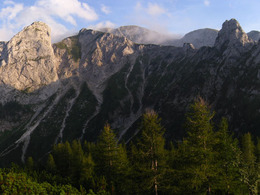
A varied steep track and an amazing "postcard panorama" - these are the reasons, why the Hochkogel a fantastic destination is.

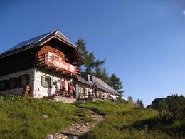
The path from the parking lot "Schwarenbach" to the Mittereckerstüberl (approximately 45 min) serves to warm up. From this popular destination leads the path 211 approximately 10 minutes to a forest road towards the end of the valley. Theres is a branch-off to the right side - the start of the climb. After a hike, which takes half an hour, you pass a spring - the "Eibenbründl" - and then you have an amazing view. Steep uphill meanders the steep track through an alley, which is between the 600 m high rock face of the Hochkogel and the extensions of the mountain Grünberg. After the achievement of the Eibelgrube, there are three giant limestones: the Hangende Kogel as well as the Vorderer and Hinterer Rauhen Kogel. The crossing of the Karwand lasts 30 minutes. On a flat transition to the Hochkogel there is the Hochkogelhaus. The climb to the summit of the Hochkogel lasts just 10 more minutes.

Hiking-time: parking lot - Hochkogelhaus: approximately 3 hours

Starting point: parking lot "Schwarzenbach"
Destination: Ebensee's Hochkogel

further information:
  • Possible accommodation

Accessibility / arrival

from the highway-departure Regau-B 145 in the direction of Bad Ischl-departure Offensee- till parking lot "Schwarzenbach"

Travelling by public transport
Route planner for independent travellers
Most economical season
  • Spring
  • Summer
  • Autumn

Please get in touch for more information.


Hochkogel in Ebensee
Tourismusbüro Ebensee
4802 Ebensee

Phone +43 6133 8016
E-Mail ebensee@traunsee-almtal.at
Web www.ebensee.com
Web www.traunsee-almtal.at
http://www.ebensee.com
http://www.traunsee-almtal.at

We speak the following languages

German

 Interactive elevation profile

Download GPS data
Create PDF

Tour-Details

Starting place: 4802 Ebensee
Destination: 4802 Ebensee

duration: 3h 15m
length: 5,7 km
Altitude difference (uphill): 1.108m
Altitude difference (downhill): 119m

Lowest point: 519m
Highest point: 1.591m
difficulty: medium
condition: difficult
panoramic view: Great panorama

Paths covering:
Hiking trail

powered by TOURDATA