Mittereckerstüberl in Ebensee
Starting place: 4802 Ebensee
Destination: 4802 Ebensee

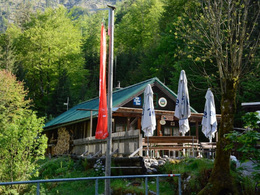
The Mittereckerstüberl, which is situated at the foot of the Hochkogel, is a popular meeting place for hikers, musicians and persons, who like the native-cooking.
Hiking-time: parking lot Schwarzenbach - Mittereckerstüberl: approximately 60 minutes
Starting place: 4802 Ebensee
Destination: 4802 Ebensee
duration: 1h 12m
length: 2,5 km
Altitude difference (uphill): 261m
Altitude difference (downhill): 30m
Lowest point: 519m
Highest point: 764m
difficulty: easy
condition: easy
panoramic view: Great panorama
Paths covering:
Hiking trail
Starting point: parking lot "Schwarzenbach"
Destination: Mittereckerstüberl
15th April till 15th September daily, mid October till end October once again daily.
0043 676/ 58 62 880 (Mittereckerstüberl and privat)
Accessibility / arrival
from the highway-departure Regau-B145 in the direction of Bad Ischl-deparutre Offensee-till parking lot "Schwarzenbach"
- Pets allowed
- Suitable for families
- Suitable for friends
- Suitable for couples
- Suitable for children
- Spring
- Summer
- Autumn
Please get in touch for more information.
4802 Ebensee
Phone +43 6133 8016
E-Mail ebensee@traunsee-almtal.at
Web www.ebensee.naturfreunde.at/service…
http://www.ebensee.naturfreunde.at/service/huetten-haeuser/mittereckerstueberl


