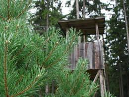
© Photo: Oberösterreich Tourismus GmbH./Robert Maybach: Enjoy the view in Upper Austria
Enjoy the view in Upper Austria
Search
Search
Close

Petersbergrunde

  • Flatly

 Interactive elevation profile

Download GPS data
Create PDF

Tour-Details

Starting place: 4172 St. Johann am Wimberg
Destination: 4172 St. Johann am Wimberg

duration: 2h 38m
length: 9,4 km
Altitude difference (uphill): 171m
Altitude difference (downhill): 176m

Lowest point: 673m
Highest point: 808m
difficulty: medium
condition: medium
panoramic view: Great panorama

Paths covering:
Asphalt, Gravel, Hiking trail

powered by TOURDATA

This hiking trail leads past large farms with marvellous views of the "Steinerne Mühl" valley and the Czech and Bavarian borders.

A wonderful hiking trail with "highs and lows". From St. Johann, the trail leads uphill on a goods road. It's worth taking a look back, you can see the village of St. Johann and, on a clear day, as far as the Alps. After leaving the goods road, the route descends along a beautiful forest hiking trail to the Hummelmühlbach stream. After a somewhat strenuous ascent, you are rewarded with a marvellous view. Take your time, breathe deeply and enjoy. From there, it's back to St. Johann.


Travelling by public transport
Route planner for independent travellers
Most economical season
  • Spring
  • Summer
  • Autumn
  • Early winter

Please get in touch for more information.


Petersbergrunde
Gemeinde St. Johann am Wimberg
St. Johann 10
4172 St. Johann am Wimberg

Phone +43 7217 7155
E-Mail gemeinde@stjohannamwimberg.at
Web www.stjohannamwimberg.at
https://www.stjohannamwimberg.at

You can also visit us on

Visit us on Facebook Visit us on Instagram Visit our videochannel on YouTube

We speak the following languages

German

 Interactive elevation profile

Download GPS data
Create PDF

Tour-Details

Starting place: 4172 St. Johann am Wimberg
Destination: 4172 St. Johann am Wimberg

duration: 2h 38m
length: 9,4 km
Altitude difference (uphill): 171m
Altitude difference (downhill): 176m

Lowest point: 673m
Highest point: 808m
difficulty: medium
condition: medium
panoramic view: Great panorama

Paths covering:
Asphalt, Gravel, Hiking trail

powered by TOURDATA