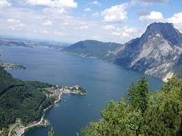
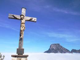
small Sonnstein in Traunkirchen
Path number: Traunsee-Almtal Wanderspass 5
Starting place: 4801 Traunkirchen
Destination: 4801 Traunkirchen

One of the favorite points of views in the Traunsee area.
Highest point: 923 m
Path number: 1
Beginning: federal 145 in Siegesbach
Refreshments: hut Sonnsteinhütte of the Mountain Rescue Services of Traunkirchen (from Easter to the end of October saturdays, sundays and at holidays, from the holiday-beginning: July and August daily open. Tel.: 0664/8797294)
Special feature: Panoramic views of the region Traunsee to the foothills of the Alps; impressive peak-cross with Christ figure of Josef Moser
From the center drive or go about 1 km in southerly direction to the village Siegesbach - at the road bridge over the Siegesbach leads right over a number of levels of well-marked path up the mountain - then along the scattered settlement on an old valley floor - at the crossroads shrine "Trinity" left through the forest - a ditch traversing - at the fork in the final stretch to the left on a steep ridge to the summit cross and the hut Sonnsteinhütte.
Connection and relegation possibilities:
● Relegation via the path Sonnsteinweg to the federal, approximately 1
● transgression to the big ( 1037m ) and relegation to Ebensee approximately 2,25
Path number: Traunsee-Almtal Wanderspass 5
Starting place: 4801 Traunkirchen
Destination: 4801 Traunkirchen
duration: 1h 43m
length: 1,8 km
Altitude difference (uphill): 407m
Altitude difference (downhill): 130m
Lowest point: 428m
Highest point: 814m
difficulty: medium
condition: medium
panoramic view: Dreamtour
Paths covering:
Hiking trail
Starting point: B 145 in Siegesbach
Destination: Sonnstein
further information:
- Board possible
hut Sonnsteinhütte of the Mountain Rescue Services of Traunkirchen (from Easter to the end of October saturdays, sundays and at holidays, from the holiday-beginning: July and August daily open. Tel.: 0664/8797294)
Accessibility / arrival
departure Regau-B145 in the direction of Bad Ischl-through Traunkirchen till Siegesbach
Parking- Parking space: 20
- Suitable for kids (10 - 14 Year)
- Pets allowed
- Suitable for single travelers
- Suitable for families
- Suitable for friends
- Suitable for couples
- Spring
- Summer
- Autumn
Please get in touch for more information.
4801 Traunkirchen
Phone +43 664 3698389
E-Mail traunkirchen@traunsee-almtal.at
Web www.sonnsteinhuette.at
Web www.wander-spass.at
http://www.sonnsteinhuette.at
http://www.wander-spass.at
http://www.wander-spass.at


