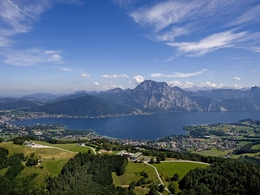
Reindlmühl – Gmundnerberg
Starting place: 4813 Altmünster
Destination: 4813 Altmünster
Easy hiking tour through forest and meadow.
Church Reindlmühl - behind GH Schachinger - uphill through grassland and forest - meadow traversing to farmhouses - follow the street on the left side - junction to the right side - above meadow - Gmundnerbergstraße (panorama panel) - Höhenstraße - regional hospital - Gmundnerberghaus - GH UrznRequirements: easy hike across forest and meadows.
Starting place: 4813 Altmünster
Destination: 4813 Altmünster
duration: 1h 15m
length: 2,4 km
Altitude difference (uphill): 270m
Altitude difference (downhill): 61m
Lowest point: 532m
Highest point: 802m
difficulty: easy
condition: easy
panoramic view: Some Views
Paths covering:
Hiking trail
Starting point: church Reindlmühl
Destination: Gmundnerberg
Accessibility / arrival
departure Regau-B145 in the direction ofBad Ischl-1km after the place name sign of Altmünster turn right in the direction of Neukirchen- through the center of Neukirchen-turn right in the direction of Reindlmühl
- Suitable for groups
- Suitable for schools
- Suitable for families
- Summer
- Autumn
Please get in touch for more information.
4812 Altmünster
Phone +43 7612 87181
E-Mail altmuenster@traunsee.at
Web www.traunsee.at/altmuenster
http://www.traunsee.at/altmuenster


